Category:Old U.S. nautical charts
Jump to navigation
Jump to search
Subcategories
This category has the following 5 subcategories, out of 5 total.
Media in category "Old U.S. nautical charts"
The following 113 files are in this category, out of 113 total.
-

-
 1836 Provincetown US Topographical Bureau.jpg 5,760 × 4,800; 1.29 MB
-
 1887 Chart of Raoul Island.png 1,024 × 671; 1.12 MB
-

-

-
-
 A chart of South Carolina and Georgia (3045498341).jpg 1,629 × 2,000; 3.15 MB
-
 A chart of South Carolina and Georgia (3045543193).jpg 1,655 × 2,000; 3.16 MB
-

-
 A chart of the banks of Newfoundland (3045499021).jpg 2,000 × 1,307; 2.58 MB
-
 A Chart of the Bar of Sandy Hook - Hills - btv1b530897996 (1 of 2).jpg 7,416 × 8,005; 8.12 MB
-

-
-
 Abaiang 1873 map.jpg 4,297 × 2,957; 5.66 MB
-
 Abaiang-Tarawa 1873 map nla obj-233983677-1 (retouched).jpg 5,000 × 7,379; 14.3 MB
-
 Abaiang-Tarawa 1873 map nla.obj-233983677-1.jpg 5,000 × 7,379; 12.38 MB
-
 Active-survey-of-Seattle-1854.jpg 8,192 × 5,222; 5.87 MB
-
 Admirality Islands - Hyane Bay - Seamap.jpg 1,793 × 711; 263 KB
-
 Aneityum 1901 Nautical Chart (cropped).jpg 5,345 × 5,172; 5.92 MB
-
 Aneityum 1901 Nautical Chart.jpg 9,316 × 7,710; 15.05 MB
-
 Aore US Nautical Chart 1950.jpg 15,020 × 10,418; 58.7 MB
-
 Atoll research bulletin (1969) (19724992143).jpg 2,928 × 2,216; 1.4 MB
-

-

-
 The coast of the United States of North America from New York to St. Augustine (NYPL b18882354-5386993).tiff 7,760 × 10,328, 2 pages; 229.57 MB
-
 The coast of the United States of North America from New York to St. Augustine (NYPL b18882354-5386994).tiff 7,760 × 10,328, 2 pages; 229.57 MB
-
 The coast of the United States of North America from New York to St. Augustine (NYPL b18882354-5386995).tiff 13,553 × 10,135; 393.22 MB
-
 Coast chart from Cape Hatteras to Cape Fear, North Carolina (NYPL b18890879-5387000).tiff 7,760 × 10,328, 2 pages; 229.57 MB
-
 Coast chart from Cape Hatteras to Cape Fear, North Carolina (NYPL b18890879-5387001).tiff 7,760 × 10,328, 2 pages; 229.57 MB
-
 Coast chart from Cape Hatteras to Cape Fear, North Carolina (NYPL b18890879-5387002).tiff 13,320 × 10,180; 388.18 MB
-
 America, N.W. Coast, Strait of Juan de Fuca (NYPL b20749013-5452693).tiff 12,786 × 10,233; 374.61 MB
-
 Cape Cod Bay Nautical Chart 1879.jpg 13,098 × 10,617; 26.31 MB
-
 Conway Reef 1901 (Ceva-i-Ra) Nautical Chart.jpg 1,473 × 1,300; 468 KB
-
 CrossIsland NashIsland 40000 1891 304-06-1891 chart.jpg 5,775 × 4,095; 8.47 MB
-
 Eldridge's chart no. 10 - Buzzard's Bay (10208126734).jpg 670 × 800; 102 KB
-

-
 Entrance to Humboldt Bay, Cal. - NARA - 100306357 (page 2).jpg 8,164 × 12,535; 4.92 MB
-
 Fatu Hiva 1920 nautical chart.jpg 4,574 × 3,843; 3.5 MB
-
 Futuna (Vanuatu) 1901 Nautical Chart.jpg 2,224 × 1,946; 1.14 MB
-
 Guadaloupe Island Alijos Rocks Roca Partida 1881 sea chart.jpg 808 × 1,296; 495 KB
-
 Hatteras Shoals Chart 1849.jpg 11,746 × 8,921; 3.7 MB
-
 Hermit Island, Carola Bay, Nautical Map.jpg 968 × 1,046; 212 KB
-
 HO -5155, Map of Western European Waters and Mediterranean Sea - NARA - 84785962.jpg 9,984 × 15,032; 12.95 MB
-
 Horn Islands cropped from Plans in the South Pacific Ocean 1951 US nautical chart.jpg 2,872 × 2,487; 3.23 MB
-
 Isle of Pines to Uen Island 1944 nautical chart.jpg 3,272 × 5,000; 2.47 MB
-
 Kingman Reef NOAA chart.jpg 6,826 × 4,543; 3.2 MB
-
 Loaita Bank nautical chart of 1911 (cropped).jpg 9,556 × 5,024; 3.18 MB
-
 Louisiade Archipelago 1922 nautical chart.jpg 8,070 × 5,638; 6.07 MB
-
 Macclesfield Bank 1920 nautical chart.jpg 4,456 × 3,444; 1.72 MB
-
 Maria Atoll cropped from Raivavae 1944 nautical chart.jpg 1,146 × 1,032; 169 KB
-
 Matthew and Hunter Islands 1901 Nautical Chart (part).jpg 3,136 × 1,936; 1.04 MB
-
 Newfoundland Bank 1787 chart.jpg 17,941 × 13,507; 152.79 MB
-
 Niuafoʻou cropped from Plans in the South Pacific Ocean 1951 US nautical chart.jpg 2,883 × 3,642; 4.39 MB
-
 Niue 1946 UK nautical chart.jpg 5,251 × 6,194; 21.83 MB
-
 Niue criopped from Plans in the South Pacific Ocean 1951 US nautical chart.jpg 2,878 × 3,190; 3.78 MB
-
 North Danger Reef nautical chart of 1911 (cropped).jpg 3,113 × 4,306; 1.05 MB
-
 NY Nantucket1947.jpeg 610 × 451; 249 KB
-
 NY nantucket1976.jpeg 596 × 427; 59 KB
-
 Long Island Sound from New York to Montock Point (NYPL b11907518-1260176).jpg 15,397 × 4,460; 9.51 MB
-
 Long Island Sound from New York to Montock Point (NYPL b11907518-1260176).tiff 15,397 × 4,460; 196.47 MB
-
 Sable Island (NYPL b13965988-2057362).tiff 5,460 × 7,320, 2 pages; 114.41 MB
-
 Sable Island (NYPL b13965988-2057364).jpg 4,621 × 6,457; 4.57 MB
-
 Sable Island (NYPL b13965988-2057364).tiff 5,430 × 7,320, 2 pages; 113.78 MB
-

-
 Mouth of Chester River - (Harbor of Refuge no. ) (NYPL b14950963-434638).tiff 5,056 × 6,285; 90.92 MB
-
 Mouth of Chester River - (Harbor of Refuge no. ) (NYPL b14950963-434638).jpg 5,056 × 6,288; 5.6 MB
-
 The harbor of Annapolis (NYPL b14950964-433902).jpg 5,851 × 4,896; 4.34 MB
-
 The harbor of Annapolis (NYPL b14950964-1260097).jpg 5,867 × 5,104; 4.79 MB
-

-

-

-
 The bay and river of Delaware (NYPL b15307887-434535).jpg 3,826 × 2,598; 1.66 MB
-
 Little Egg Harbor (NYPL b15328012-434935).tiff 5,112 × 5,939; 86.87 MB
-
 Little Egg Harbor (NYPL b15328012-483733).tiff 5,112 × 5,939; 86.87 MB
-

-

-

-

-

-

-

-

-

-

-

-

-

-

-
 Preliminary chart of the sea coast of part of Alabama and Mississippi (NYPL b19561224-5247811).tiff 10,328 × 7,760, 2 pages; 229.57 MB
-
 America, N.W. Coast, Strait of Juan de Fuca (NYPL b20749013-5452692).tiff 7,760 × 10,328, 2 pages; 229.61 MB
-

-
 Pearl Lochs and Puuloa Entrance, 1873.jpg 1,479 × 2,013; 399 KB
-
 Pinipel-CS-1813.jpg 4,051 × 5,309; 2.33 MB
-
 Plans in the South Pacific Ocean 1951 US nautical chart.jpg 6,154 × 8,909; 21.39 MB
-
 Plans of Islands in the South Pacific - UK 1946 nautical chart.jpg 12,624 × 16,624; 124.81 MB
-
 Port Inyeug 1901 US Nautical Chart (part).jpg 3,722 × 7,077; 5.86 MB
-
 Pratas Atoll nautical chart 1946.jpg 6,300 × 4,405; 3.08 MB
-
 Puertogalera chart 4344 1917.jpeg 3,626 × 3,213; 1.69 MB
-
 Puertoprincesa chart4343 1904.jpeg 3,053 × 2,561; 1.31 MB
-
 Raivavae 1944 nautical chart.jpg 7,286 × 5,489; 4.22 MB
-
 Recherche Archipelago 1977 nautical chart.jpg 8,543 × 6,230; 8.05 MB
-
 Roca Partida 1881 sea chart.jpg 392 × 648; 127 KB
-
 Rose Atoll NOAA chart.jpg 1,211 × 1,275; 394 KB
-
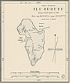 Rurutu cropped fromRaivavae 1944 nautical chart.jpg 1,074 × 1,278; 225 KB
-
 Spratly Islands partial nautical charts of 1911.jpg 11,776 × 16,480; 11.87 MB
-
 Tarawa 1873 map.jpg 4,277 × 3,473; 5.41 MB
-
 Thitu Reefs and Subi Reef nautical chart of 1911 (cropped).jpg 6,532 × 4,321; 1.91 MB
-
 Tizard Bank nautical chart of 1911 (cropped).jpg 9,559 × 5,312; 3.47 MB
-
 Track chart of H.M.S. Torch Ningpo , October & November 1854.jpg 3,600 × 4,615; 2.35 MB
-

-
 USCGS Chart number 361 (1884).jpg 10,400 × 13,200; 11.86 MB
-
 Walpole Island 1901 US Nautical Chart (part).jpg 1,030 × 1,925; 421 KB
-

.jpg)


.jpg)
.jpg)
.jpg)
.jpg)
.jpg)
.jpg)
.jpg)
.jpg)
.jpg)

.jpg)


.jpg)


_(19724992143).jpg)
.jpg)
.jpg)

_Nautical_Chart.jpg)

.jpg)

.jpg)

_1901_Nautical_Chart.jpg)


.jpg)


.jpg)


.jpg)


.jpg)
.jpg)
_(NYPL_b14950963-434638).jpg)
.jpg)
.jpg)
.jpg)
.jpg)
.jpg)
.jpg)
.jpg)
.jpg)
.jpg)
.jpg)
.jpg)
.jpg)
.jpg)
.jpg)


.jpg)


.jpg)
.jpg)


.jpg)
.jpg)
.jpg)
.jpg)
.jpg)