Category:November 2020 in the East Riding of Yorkshire
Jump to navigation
Jump to search
Ceremonial counties of England: Berkshire · Buckinghamshire · Cambridgeshire · Cornwall · Devon · Dorset · East Riding of Yorkshire · East Sussex · Essex · Gloucestershire · Greater London · Greater Manchester · Hampshire · Hertfordshire · Isle of Wight · Kent · Lancashire · Merseyside · Norfolk · North Yorkshire · Northumberland · Somerset · Suffolk · Surrey · Warwickshire · West Midlands · West Yorkshire ·
City-counties:
Former historic counties:
Other former counties:
City-counties:
Former historic counties:
Other former counties:
Deutsch: Bilder, die im November 2020 in the East Riding of Yorkshire aufgenommen worden sind. Bitte beachten Sie, dass dies weder das Datum des Uploads noch das Datum des Scannens eines Fotos ist.
English: Images/pictures taken in the East Riding of Yorkshire during November 2020. Note this is not the date of the upload, nor the date a photo was scanned.
Español: Fotografías o imágenes tomadas en the East Riding of Yorkshire durante noviembre 2020. No es la fecha de subida ni escaneo, sino la fecha en que las fotografías o imágenes se crearon.
Esperanto: Bildoj faritaj en the East Riding of Yorkshire en novembro 2020. Tio ne estas la dato, kiam la bildoj estis alŝutitaj aŭ skanitaj.
Français : Photographies ou images prises en the East Riding of Yorkshire durant novembre 2020. Ce n'est pas la date du téléchargement ou du scan.
Galego: Fotografías ou imaxes tomadas en the East Riding of Yorkshire durante novembro 2020. Non é a data de subida nin escaneamento, senón a data na que se crearon as fotografías ou imaxes.
Italiano: Fotografie o immagini scattate a the East Riding of Yorkshire nel novembre 2020. Nota bene: la data non si riferisce né a quella di upload né a quella in cui la foto è stata digitalizzata.
Norsk bokmål: Bilder tatt i the East Riding of Yorkshire i løpet av november 2020. Merk at dette ikke er datoen for opplasting, eller når et bilde har blitt skannet.
Norsk nynorsk: Bilete teke i the East Riding of Yorkshire i løpet av november 2020. Merk at dette ikkje er datoen for opplasting, eller når eit bilete har vorte skanna.
Русский: Изображения, сделанные в the East Riding of Yorkshire в течение ноябрь 2020 (не дата загрузки изображения).
Українська: Зображення, зроблені в the East Riding of Yorkshire протягом листопад 2020. Зауважте, що це не дата завантаження чи дата сканування фотографії.
| November 2019 | ← | November 2020 | → | November 2021 | |||||||
| Jan | Feb | Mar | Apr | May | Jun | Jul | Aug | Sep | Oct | Nov | Dec |
| 171 | 19 | 30 | 77 | 119 | 168 | 38 | 37 | 27 | 20 | 24 | 4 |
|---|---|---|---|---|---|---|---|---|---|---|---|
Media in category "November 2020 in the East Riding of Yorkshire"
The following 24 files are in this category, out of 24 total.
-
 Approaching High Hunsley on B1230 (geograph 6682646).jpg 1,447 × 1,086; 343 KB
-
 Beverley Road, Withernwick (geograph 6685306).jpg 1,024 × 824; 129 KB
-
 Cowden lane (geograph 6685236).jpg 1,024 × 768; 175 KB
-
 Eastgrowths Farm (geograph 6688295).jpg 1,024 × 768; 103 KB
-
 Entrance to West Hill (geograph 6685283).jpg 1,024 × 768; 200 KB
-
 Field path towards Withernwick (geograph 6685220).jpg 1,024 × 768; 112 KB
-
 Footpath by the drain (geograph 6685227).jpg 1,024 × 768; 188 KB
-
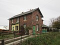 Former Whitedale station house. Now a private residence (geograph 6675434).jpg 4,608 × 3,456; 3.82 MB
-
 From Yorkshire Wolds to Vale of York down B1230 - geograph.org.uk - 6683700.jpg 2,095 × 1,570; 858 KB
-
 Glebe farm barns (geograph 6685239).jpg 1,024 × 768; 108 KB
-
 High Hunsley Farm on The Avenue B1230 (geograph 6682654).jpg 1,781 × 1,336; 695 KB
-
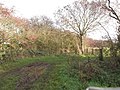
 Hornsea Rail Trail toward Whitedale station (geograph 6675483).jpg 4,608 × 3,456; 4.18 MB
-
 Long straight on the B1230 toward High Hunsley (geograph 6682624).jpg 1,552 × 1,164; 248 KB
-
 Near the end of a muddy path (geograph 6685234).jpg 1,024 × 768; 308 KB
-
 Old Wife Lane (geograph 6685273).jpg 1,024 × 768; 273 KB
-
 Our Lady and St Peter's Church front, Bridlington by Beryl Gallagher.jpg 4,608 × 3,456; 6.33 MB
-
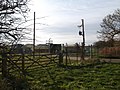
 Platforms either side of Hornsea Rail Trail (geograph 6675459).jpg 4,608 × 3,456; 5.75 MB
-
 St Albans Church, Withernwick (geograph 6685212).jpg 1,024 × 768; 190 KB
-
 The former Whitedale Station on the Hornsea Rail Trail (geograph 6675472).jpg 4,608 × 3,456; 5.63 MB
-
 Winter arable crop and East Plantation from B1230 (geograph 6682635).jpg 1,431 × 1,073; 331 KB
-
 Withernwick sewage works (geograph 6685230).jpg 1,024 × 768; 240 KB
-
 Withernwick Wind Farm (geograph 6685274).jpg 1,024 × 768; 127 KB
-
 Withernwick Wind Farm (geograph 6685276).jpg 1,024 × 768; 106 KB
-
 York Road towards Kilham - geograph.org.uk - 6662378.jpg 1,024 × 655; 96 KB
.jpg)
.jpg)
.jpg)
.jpg)
.jpg)
.jpg)
.jpg)
.jpg)

.jpg)
.jpg)
.jpg)
.jpg)
.jpg)
.jpg)

.jpg)
.jpg)
.jpg)
.jpg)
.jpg)
.jpg)
.jpg)
