Category:Nederlands Hervormde Kerk (Leidschendam)
Jump to navigation
Jump to search
| Object location | | View all coordinates using: OpenStreetMap |
|---|
church building in Leidschendam, the Netherlands  | |||||
| Upload media | |||||
| Instance of | |||||
|---|---|---|---|---|---|
| Location | Leidschendam, Leidschendam-Voorburg, South Holland, Netherlands | ||||
| Street address |
| ||||
| Located on street |
| ||||
| Architect | |||||
| Heritage designation |
| ||||
| Inception |
| ||||
| Significant event |
| ||||
 | |||||
Nederlands: Dorpskerk Leidschendam - anno 1653/1696
|
This is a category about rijksmonument number 25706
|
| Address |
|
Media in category "Nederlands Hervormde Kerk (Leidschendam)"
The following 30 files are in this category, out of 30 total.
-
 Bovenste deel voorzijde - Leidschendam - 20323397 - RCE.jpg 1,200 × 869; 151 KB
-
 Dorpskerk en sluis.JPG 3,648 × 2,432; 2.54 MB
-
 Exterieur - Leidschendam - 20138005 - RCE.jpg 917 × 1,200; 195 KB
-
 Exterieur - Leidschendam - 20138018 - RCE.jpg 956 × 1,200; 276 KB
-
 Exterieur naar het noord-westen - Leidschendam - 20138006 - RCE.jpg 954 × 1,200; 200 KB
-
 Exterieur overzicht naar het noord-oosten - Leidschendam - 20138007 - RCE.jpg 1,200 × 952; 305 KB
-
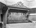 Herenbank - Leidschendam - 20138010 - RCE.jpg 1,200 × 950; 219 KB
-
 Herenbank - Leidschendam - 20138011 - RCE.jpg 890 × 1,200; 198 KB
-
 Hs.Verhees - Leidschendam - 20138004 - RCE.jpg 844 × 1,200; 187 KB
-
 Interieur met orgel - Leidschendam - 20138009 - RCE.jpg 948 × 1,200; 171 KB
-
 Interieur naar het westen - Leidschendam - 20138008 - RCE.jpg 961 × 1,200; 160 KB
-
 Interieur, aanzicht orgel, orgelnummer 864 - Leidschendam - 20417260 - RCE.jpg 806 × 1,200; 196 KB
-
 Leidschendam - Deltsekade 7.jpg 1,574 × 2,040; 842 KB
-
 Leidschendam - Sluisplein 14.jpg 2,592 × 1,944; 1.21 MB
-
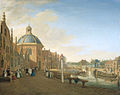
 Leidschendam aan de Vliet.jpg 855 × 1,140; 136 KB
-
 Leidschendam dorpskerk.jpg 1,110 × 1,071; 114 KB
-
 Leidschendam, NH kerk RM25706 en ophaalbrug RM385566 foto2 2012-05-13 11.06.jpg 4,359 × 3,261; 3.57 MB
-

-
 Overzicht - Leidschendam - 20365085 - RCE.jpg 1,200 × 1,200; 314 KB
-
 Overzicht met brugwachtershuisje - Leidschendam - 20137994 - RCE.jpg 950 × 1,200; 230 KB
-

-
-
 Preekstoel - Leidschendam - 20138013 - RCE.jpg 830 × 1,200; 190 KB
-
 Preekstoel - Leidschendam - 20138017 - RCE.jpg 974 × 1,200; 207 KB
-
 Preekstoel en doophek - Leidschendam - 20138012 - RCE.jpg 1,200 × 756; 158 KB
-
 Preekstoel, panelen - Leidschendam - 20138014 - RCE.jpg 854 × 1,200; 306 KB
-
 Preekstoel, panelen - Leidschendam - 20138015 - RCE.jpg 911 × 1,200; 307 KB
-
 Preekstoel, panelen - Leidschendam - 20138016 - RCE.jpg 846 × 1,200; 283 KB
-
 Protestantse Dorpskerk te Leidschendam.jpg 407 × 506; 45 KB
-


_van_P.C.Fargue_in_het_Archief_Leiden_-_Leidschendam_-_20138003_-_RCE.jpg)


