Category:Muness
Jump to navigation
Jump to search
English: Muness is a hamlet on the island of Unst, in the council area of the Shetland Islands, Scotland.
Subcategories
This category has the following 3 subcategories, out of 3 total.
H
- Ham Ness (30 F)
- Hunts Holm, Muness (6 F)
M
- Muness Castle (68 F)
Media in category "Muness"
The following 132 files are in this category, out of 132 total.
-
 Approaching shower, Muness - geograph.org.uk - 2133927.jpg 800 × 534; 115 KB
-
 Back Geo, Quida, Muness - geograph.org.uk - 3432291.jpg 681 × 1,024; 223 KB
-
 Banks, Ham Ness - geograph.org.uk - 3169488.jpg 1,024 × 681; 260 KB
-
 Beach at the Pool, Ham Ness - geograph.org.uk - 3169502.jpg 1,024 × 682; 218 KB
-
 Braewick Stack, Muness - geograph.org.uk - 2013213.jpg 640 × 427; 30 KB
-
 Brei Wick, Ham Ness - geograph.org.uk - 3169869.jpg 1,024 × 682; 245 KB
-
 Brei Wick, Muness - geograph.org.uk - 4492958.jpg 1,024 × 681; 193 KB
-
 Breiwick Stack, Ham Ness - geograph.org.uk - 3169879.jpg 1,024 × 681; 244 KB
-
 Breiwick Stack, Ham Ness - geograph.org.uk - 3169895.jpg 1,024 × 681; 219 KB
-
 Brough from Muness - geograph.org.uk - 5222024.jpg 1,024 × 684; 95 KB
-
 Burn at Scolla Wick, Muness - geograph.org.uk - 2243075.jpg 533 × 800; 232 KB
-
 Burn flowing into Scolla Wick - geograph.org.uk - 3978390.jpg 2,048 × 1,536; 1.61 MB
-
 Clouds along the east coast of Unst - geograph.org.uk - 3810347.jpg 1,024 × 682; 75 KB
-
 Coast at Ore Wick between Uyeasound and Muness - geograph.org.uk - 3432373.jpg 1,024 × 681; 226 KB
-
 Coastline east of Scolla Wick, Muness - geograph.org.uk - 4817469.jpg 1,024 × 682; 227 KB
-
 Cottage at Castleton - geograph.org.uk - 3467010.jpg 480 × 640; 75 KB
-
 Croft land, Muness - geograph.org.uk - 3817307.jpg 640 × 360; 194 KB
-
-

-

-
 Drain at Scolla, Muness - geograph.org.uk - 2243129.jpg 534 × 800; 242 KB
-
 Drainage ditch west of Ramnagoe, Muness - geograph.org.uk - 3432336.jpg 681 × 1,024; 255 KB
-
 East coast of Mu Ness - geograph.org.uk - 3169938.jpg 1,024 × 681; 198 KB
-
 East coast of Mu Ness from Hestibanks - geograph.org.uk - 3169979.jpg 1,024 × 681; 195 KB
-
 East coast of Unst from Muness - geograph.org.uk - 3826401.jpg 1,024 × 681; 140 KB
-
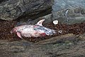
 Eye of a whale, Scolla Wick, Muness - geograph.org.uk - 3881814.jpg 682 × 1,024; 214 KB
-
 Fauld, Ramnageo, Muness - geograph.org.uk - 3432331.jpg 1,024 × 681; 208 KB
-
 Fauld, Ramnageo, Muness - geograph.org.uk - 3432345.jpg 1,024 × 681; 155 KB
-
 Fauld, Ramnageo, Muness - geograph.org.uk - 4817489.jpg 1,024 × 682; 212 KB
-
 Fauld, Ramnagoe, Muness - geograph.org.uk - 3432334.jpg 1,024 × 684; 179 KB
-
 Fence at Hannigarth, Unst - geograph.org.uk - 2801123.jpg 800 × 532; 247 KB
-
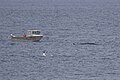
 Ferry passing Muness - geograph.org.uk - 865254.jpg 640 × 419; 68 KB
-
 Fin of a whale, Scolla Wick, Muness - geograph.org.uk - 3881824.jpg 1,024 × 681; 155 KB
-
 Footpath sign - geograph.org.uk - 3978373.jpg 2,048 × 1,536; 1.14 MB
-
 Footpath to the Beach - geograph.org.uk - 4811059.jpg 1,600 × 1,059; 447 KB
-
 Former Nornova knitwear shop, Muness - geograph.org.uk - 4732005.jpg 1,024 × 576; 168 KB
-
 Fulmar (Fulmarus glacialis), Scolla Wick, Muness - geograph.org.uk - 3888846.jpg 1,024 × 678; 119 KB
-

-

-

-
 Gorse Geos, Ness of Ramnageo, Muness - geograph.org.uk - 3432327.jpg 1,024 × 682; 213 KB
-
 Grassland, Mid Field - geograph.org.uk - 3817320.jpg 640 × 480; 253 KB
-
 Grazing sheep - geograph.org.uk - 3978361.jpg 2,048 × 1,536; 613 KB
-
 Ham Beach, Muness - geograph.org.uk - 3169420.jpg 1,024 × 683; 238 KB
-
 Ham Beach, Muness - geograph.org.uk - 3169444.jpg 1,024 × 683; 257 KB
-
 Ham beach, Muness - geograph.org.uk - 3169460.jpg 1,024 × 684; 311 KB
-
 Ham Booth, Ham of Muness - geograph.org.uk - 3169467.jpg 1,024 × 682; 198 KB
-
 Ham Geo - geograph.org.uk - 2096492.jpg 3,888 × 2,592; 4.14 MB
-
 Ham Ness from Muness - geograph.org.uk - 3170047.jpg 1,024 × 681; 130 KB
-
 Ham Ness from Muness Castle - geograph.org.uk - 2793366.jpg 800 × 532; 208 KB
-
 Ham Ness in a strong easterly - geograph.org.uk - 3260667.jpg 1,024 × 680; 144 KB
-
 Ham of Muness - geograph.org.uk - 3169472.jpg 1,024 × 681; 190 KB
-
 Ham of Muness - geograph.org.uk - 319174.jpg 600 × 395; 54 KB
-
 Ham of Muness - geograph.org.uk - 3467021.jpg 640 × 480; 65 KB
-
 Ham of Muness - geograph.org.uk - 865229.jpg 640 × 426; 123 KB
-
 Ham of Muness and Ham Ness - geograph.org.uk - 3169414.jpg 1,024 × 681; 141 KB
-
 Helli Geo, Quida, Muness - geograph.org.uk - 3432286.jpg 1,024 × 681; 154 KB
-
 Hestibanks and Hunts Holm, Mu Ness - geograph.org.uk - 3170023.jpg 1,024 × 682; 158 KB
-
 Hestibanks, Muness - geograph.org.uk - 2243110.jpg 800 × 534; 212 KB
-
 Heyback, Ham Ness - geograph.org.uk - 3169564.jpg 1,024 × 682; 277 KB
-
 Heyback, Ham Ness - geograph.org.uk - 3169566.jpg 1,024 × 682; 212 KB
-
 High seas off Muness - geograph.org.uk - 3260661.jpg 1,024 × 681; 154 KB
-
 Jaw of a whale, Scolla Wick, Muness - geograph.org.uk - 3881818.jpg 1,024 × 681; 181 KB
-
 Killer Whale (Orcinus orca), Muness - geograph.org.uk - 5102792.jpg 1,024 × 682; 151 KB
-
 Killer Whales (Orcinus orca), Muness - geograph.org.uk - 5102780.jpg 1,024 × 682; 219 KB
-
 Little Ham, Ham of Muness - geograph.org.uk - 3169450.jpg 1,024 × 681; 283 KB
-
 Longa Geo, Muness - geograph.org.uk - 3432296.jpg 1,024 × 681; 169 KB
-

-
 Looking south from Hestibanks, Muness - geograph.org.uk - 2243116.jpg 800 × 534; 194 KB
-
 Meadowland at Muness, Unst - geograph.org.uk - 354823.jpg 640 × 442; 58 KB
-
-
 Moorland, Uyea Break - geograph.org.uk - 3817327.jpg 640 × 480; 260 KB
-
 Muckle Selli Geo, Muness - geograph.org.uk - 3432298.jpg 1,024 × 682; 180 KB
-
 Muness - geograph.org.uk - 311536.jpg 600 × 398; 41 KB
-

-
 MV Gripfisk passing Ness of Ramnageo, Muness - geograph.org.uk - 3432349.jpg 1,024 × 681; 134 KB
-
 North House, Muness - geograph.org.uk - 2243057.jpg 800 × 534; 186 KB
-
 Noustigarth, Muness - geograph.org.uk - 2243122.jpg 800 × 532; 175 KB
-
 Ore Wick, between Uyeasound and Muness - geograph.org.uk - 3432368.jpg 1,024 × 681; 170 KB
-
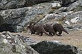 Otter family, Muness - geograph.org.uk - 3432306.jpg 1,024 × 683; 205 KB
-
 Path to Ham Beach - geograph.org.uk - 3928144.jpg 1,280 × 851; 246 KB
-
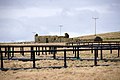
 Ponies at Muness - geograph.org.uk - 3260658.jpg 1,024 × 682; 135 KB
-
 Ponies on the moor - geograph.org.uk - 3978483.jpg 2,048 × 1,536; 1.63 MB
-
 Rams at Muness - geograph.org.uk - 2931526.jpg 800 × 532; 139 KB
-
 Reasings, Mu Ness - geograph.org.uk - 3169916.jpg 1,024 × 681; 256 KB
-
 Road to Ramnageo - geograph.org.uk - 3978472.jpg 2,048 × 1,536; 611 KB
-

-
 Rocky coastline on the east side of Ham Ness - geograph.org.uk - 3169642.jpg 1,024 × 682; 259 KB
-
 Rope on the Wall - geograph.org.uk - 4744158.jpg 1,600 × 900; 300 KB
-
 Ruin on the shore of Ham of Muness - geograph.org.uk - 3169474.jpg 1,024 × 681; 210 KB
-

-

-
 Ruined croft house, Muness - geograph.org.uk - 3817305.jpg 640 × 360; 210 KB
-
 Ruined crofthouse, Muness - geograph.org.uk - 2842796.jpg 800 × 533; 205 KB
-
 Ruined House by the Sea - geograph.org.uk - 4769308.jpg 3,802 × 2,496; 3.22 MB
-
 Scolla Wick, Muness - geograph.org.uk - 2243062.jpg 800 × 533; 247 KB
-
 Scolla Wick, Muness - geograph.org.uk - 2243072.jpg 800 × 533; 167 KB
-
 Scolla Wick, Muness - geograph.org.uk - 3881787.jpg 1,024 × 681; 204 KB
-
 Scolla Wick, Muness - geograph.org.uk - 3881804.jpg 1,024 × 681; 219 KB
-
 Scolla Wick, Muness - geograph.org.uk - 3891899.jpg 1,024 × 681; 178 KB
-
 Scolla Wick, Muness - geograph.org.uk - 4817474.jpg 1,024 × 682; 233 KB
-
 Scolla Wick, Muness, from the west - geograph.org.uk - 3432309.jpg 1,024 × 682; 128 KB
-
 Scolla, Muness - geograph.org.uk - 2243047.jpg 800 × 534; 171 KB
-
 Scranklings, Ness of Ramnageo - geograph.org.uk - 2193875.jpg 800 × 533; 196 KB
-
 Sea cliffs at Mu Ness - geograph.org.uk - 1971833.jpg 2,816 × 2,112; 2.61 MB
-

-
 Sheep at Muness - geograph.org.uk - 5769321.jpg 1,024 × 683; 87 KB
-
 Sheltering sheep, Muness - geograph.org.uk - 3826428.jpg 1,024 × 681; 164 KB
-
 Shetland ponies on Mid Field, Muness - geograph.org.uk - 2947492.jpg 800 × 532; 160 KB
-

-
 Silage at Muness - geograph.org.uk - 529201.jpg 640 × 426; 45 KB
-

-
 Soggy field at Mid Field - geograph.org.uk - 3467005.jpg 640 × 480; 104 KB
-
 South Mu Ness - geograph.org.uk - 5009184.jpg 2,592 × 1,944; 1.66 MB
-
 Stack of Kidgeo, Mu Ness - geograph.org.uk - 3169924.jpg 1,024 × 681; 216 KB
-
 Sunset from Breck of Muness - geograph.org.uk - 3444163.jpg 1,024 × 681; 49 KB
-
 Taing of Noustigarth, Muness - geograph.org.uk - 2243090.jpg 800 × 534; 241 KB
-
 Taing of Noustigarth, Muness - geograph.org.uk - 2243126.jpg 800 × 534; 161 KB
-
 The end of Ham Ness - geograph.org.uk - 3169522.jpg 1,024 × 681; 184 KB
-
 The end of Ham Ness - geograph.org.uk - 3169557.jpg 1,024 × 682; 189 KB
-
 The Raabs, Ness of Littlegarth, Muness - geograph.org.uk - 3432353.jpg 1,024 × 681; 190 KB
-
 The road to Muness - geograph.org.uk - 3466998.jpg 640 × 480; 84 KB
-
 View across Scolla Wick, Muness - geograph.org.uk - 2243080.jpg 800 × 534; 200 KB
-
 View north from Muness - geograph.org.uk - 4448310.jpg 1,024 × 680; 66 KB
-
 View north from Muness - geograph.org.uk - 557322.jpg 640 × 426; 29 KB
-
 View to Balta from Mu Ness - geograph.org.uk - 3169994.jpg 1,024 × 683; 161 KB
-
 View to Haaf Gruney from Muness - geograph.org.uk - 2243052.jpg 800 × 534; 150 KB
-

-
 Wick of Fauld, Ramnageo, Muness - geograph.org.uk - 3432346.jpg 1,024 × 681; 224 KB
-
 Wick of Fauld, Ramnagoe, Muness - geograph.org.uk - 3432341.jpg 1,024 × 681; 230 KB
-
 Yacht passing Muness - geograph.org.uk - 1948844.jpg 800 × 534; 143 KB
-


,_Scolla_Wick,_Muness_-_geograph.org.uk_-_2243068.jpg)
,_Scolla_Wick,_Muness_-_geograph.org.uk_-_3881775.jpg)
,_Scolla_Wick,_Muness_-_geograph.org.uk_-_3881781.jpg)


,_Scolla_Wick,_Muness_-_geograph.org.uk_-_3888846.jpg)
,_off_the_Taing_of_Noustigarth,_Muness_-_geograph.org.uk_-_3888855.jpg)
,_off_the_Taing_of_Noustigarth,_Muness_-_geograph.org.uk_-_3888862.jpg)
,_Scolla_Wick,_Muness_-_geograph.org.uk_-_3888850.jpg)


,_Muness_-_geograph.org.uk_-_5102792.jpg)
,_Muness_-_geograph.org.uk_-_5102780.jpg)


_next_to_a_small_boat,_Muness_-_geograph.org.uk_-_5879276.jpg)


,_east_coast_of_Mu_Ness_-_geograph.org.uk_-_3169957.jpg)


,_Trolla_Skerry,_Muness_-_geograph.org.uk_-_3432304.jpg)