Category:Maps of the indigenous peoples of North America
Jump to navigation
Jump to search
Subcategories
This category has the following 5 subcategories, out of 5 total.
*
H
M
Media in category "Maps of the indigenous peoples of North America"
The following 84 files are in this category, out of 84 total.
-
 1562-Diego Gutiérrez.jpg 1,302 × 989; 560 KB
-

-
 1718 Carte de la Louisiane et du Cours du Mississipi by Guillaume Delisle.jpg 8,313 × 6,326; 11.27 MB
-
 1850 Tallis - Rapkin Map of the United States - Geographicus - USA-tlls-1850.jpg 2,737 × 2,045; 1.5 MB
-

-
-
-

-
 1900 Map - Chicagoland Indian Trails of 1804 by Scharf.jpg 2,760 × 3,304; 1.71 MB
-

-

-
 AdamsNE-KenesawTownship.png 350 × 355; 8 KB
-
 Anishinaabewaki.jpg 1,056 × 816; 565 KB
-
 Arctic cultures 900-1500.png 259 × 989; 251 KB
-
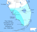 Calusa-Chiefdom-Map.svg 1,600 × 1,400; 2.07 MB
-
 Carte des pays situes à l'ouest du Canada 1791.jpg 1,920 × 1,376; 894 KB
-
 CocopahTerritory.gif 318 × 219; 20 KB
-
 Density and frequency haplogroup R.jpg 852 × 495; 95 KB
-
 Early indian complete.jpg 3,132 × 2,000; 1.24 MB
-
 Efmo map of effigy mound culture.png 200 × 357; 54 KB
-
 Etnias antiguas de Chihuahua.png 2,148 × 2,324; 793 KB
-
 Federally recognized tribes by state.svg 959 × 593; 58 KB
-
 Florida 1710-1720.jpg 1,542 × 1,321; 2.45 MB
-
 Guaxcabanes y Sauzas.png 804 × 625; 116 KB
-
 Haudenosaunee Territory.png 2,000 × 2,000; 366 KB
-
 Home 010.jpg 1,700 × 2,338; 1.13 MB
-
 Indian Population in the United States and Alaska (1910) (14597213268).jpg 2,510 × 2,911; 1.51 MB
-
 Indian Population in the United States and Alaska (1910) (14783859745).jpg 2,126 × 1,404; 829 KB
-
 Indians NW of South Carolina.jpg 1,770 × 1,217; 294 KB
-
 Indians of Manhattan Island and vicinity - (1921) (14782411534).jpg 2,032 × 2,392; 310 KB
-
 Indigenous Americans by state.svg 1,199 × 593; 73 KB
-
 Karte-Prärie-Indianer-Pferd-und-Bison.png 733 × 962; 473 KB
-
 Kikiallus Territory.png 1,130 × 1,080; 237 KB
-
 Lenape Languages.png 1,182 × 1,387; 500 KB
-
 Les nations autochtones et le Québec.jpg 2,406 × 3,324; 1.46 MB
-
 Lushootseed area.png 2,095 × 2,159; 958 KB
-
 Map Ethnographic map of North America 1928-1940 - Touring Club Italiano CART-TRC-30.jpg 6,611 × 7,997; 6.1 MB
-
 Map of Innu nations.svg 512 × 435; 55 KB
-
 Map of Snohomish Territory.png 1,130 × 1,080; 252 KB
-
 Map of Stillaguamish Territory.png 1,645 × 1,056; 282 KB
-
 Map of the Colony of Rhode Island giving the Indian names of locations.jpg 8,418 × 11,284; 37.12 MB
-
 Mocama-People-Map.png 2,571 × 1,699; 204 KB
-
 Native American and Alaska Native World War II veterans.pdf 2,587 × 1,687; 2.62 MB
-
 Native American CENSUS map.gif 575 × 425; 9 KB
-
 Native american majority and plurality Arizona county map.JPG 568 × 649; 69 KB
-

-
 Native American tribal recognition by state.png 2,000 × 1,237; 193 KB
-
 Native American tribal recognition by state.svg 959 × 593; 58 KB
-
 Native American with table.jpg 622 × 546; 83 KB
-
 Native americans in Montana counties map.JPG 800 × 491; 39 KB
-
 Native Americans in Nebraska counties.PNG 558 × 345; 4 KB
-
 Native americans in new mexico counties.PNG 241 × 232; 5 KB
-
 Native americans in north dakota.PNG 812 × 484; 65 KB
-
 Native americans in south dakota.PNG 813 × 502; 60 KB
-
 Native americans in utah counties.PNG 217 × 259; 13 KB
-
 Native americans in wisconsin counties.PNG 221 × 225; 17 KB
-
 Native Americans Race.png 1,749 × 1,740; 124 KB
-
 Nochistlan.png 326 × 316; 177 KB
-
 Nordamerikanische Kulturareale ar.png 1,490 × 1,700; 745 KB
-
 North American cultural areas.png 1,490 × 1,700; 708 KB
-
 Numbered-Treaties-Map.svg 1,005 × 690; 111 KB
-
 Paramountcy of Coosa.jpg 1,048 × 763; 162 KB
-
 Percentage of Amerindian Population.png 565 × 600; 78 KB
-
 Percentage of state populations identifying as Native American 2012.svg 1,530 × 990; 13.64 MB
-
 PSM V82 D443 Map of the area of the plains indians.png 1,640 × 1,641; 235 KB
-
 Pueblos del Noreste de Mexico.jpg 700 × 382; 123 KB
-
 Québec vers 1710.jpg 3,264 × 1,836; 2.54 MB
-
 Sarcee01.png 1,593 × 1,564; 3.55 MB
-
 Skykomish lands (~19th century).png 1,371 × 1,080; 226 KB
-
 Snoqualmie territory.png 1,575 × 1,080; 217 KB
-
 South Carolina 1710-1720.jpg 1,236 × 854; 1.35 MB
-
 Susquehannock lang.png 497 × 310; 28 KB
-
 Texas yaquis migrations, 1850 to 1900.jpg 682 × 406; 60 KB
-

-

-

-

-

-
 Untitled-report 1434041289037 block 0.png 1,200 × 675; 134 KB
-
 US AIAN 2008 map.gif 575 × 425; 10 KB
-
 Waban-Aki.png 727 × 466; 88 KB
-
 Wpdms carolina colony grant.png 300 × 260; 36 KB
-
 Young folks' history of the United States (1903) (14775227994).jpg 2,008 × 2,956; 756 KB
-
 Long & Carey & Lea Country Drained by the Mississippi, Western Section 1823 UTA.jpg 2,892 × 4,390; 9.65 MB

%27_(11211386924).jpg)


_-_Geographicus_-_NorthAmerica-tallis-1850.jpg)
_-_Geographicus_-_UnitedStates-tallis-1850.jpg)
_-_Geographicus_-_WestCanada-tallis-1850.jpg)


%27_(11211239535).jpg)


_(14597213268).jpg)
_(14783859745).jpg)

_(14782411534).jpg)


.png)


_(14565814508).jpg)
_(20781281521).jpg)
_(14593391219).jpg)
_(14777697884).jpg)


_(14775227994).jpg)

.jpg)