Category:Maps of the history of the Persian Gulf
Jump to navigation
Jump to search
Subcategories
This category has the following 3 subcategories, out of 3 total.
O
- Old maps of Abu Musa Island (6 F)
- Old maps of Qeshm Island (6 F)
Media in category "Maps of the history of the Persian Gulf"
The following 18 files are in this category, out of 18 total.
-

-
 Al-thwaini campaign in Arabia.svg 664 × 612; 2.72 MB
-
 Arabian Peninsula-565-es.svg 1,104 × 1,030; 1.12 MB
-
 Arabian Peninsula-565-pt.svg 341 × 348; 12 KB
-
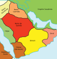
 Elam-.jpg 555 × 480; 24 KB
-
 Iran(Persia) and Caucasus.jpg 6,085 × 8,796; 8.42 MB
-
 Kingdom of Ormuz.png 1,176 × 818; 508 KB
-
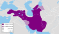 Median Empire-The first half of the 6th century BC.png 1,619 × 925; 214 KB
-
 Persian Gulf PT1.png 900 × 494; 646 KB
-
 Persian Gulf Pt8.png 900 × 494; 654 KB
-
 Persian Gulf z1507-1750.gif 900 × 494; 273 KB
-
 Portuguese Arabia V17.png 1,378 × 1,035; 152 KB
-
 Portuguese Arabia V18.png 1,023 × 993; 143 KB
-
 Portuguese Arabia V20.png 800 × 777; 166 KB
-
 Portuguese Empire V30.png 800 × 777; 212 KB
-
 Portuguese Empire V31.png 800 × 777; 176 KB
-
 Portuguese Empire V33.png 800 × 777; 177 KB
-
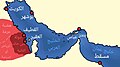 موانئ الخليج العربي في عهد الإمارة الخالدية الثانية.jpg 1,080 × 602; 125 KB
%27_(11299835965).jpg)


_and_Caucasus.jpg)


