Category:Maps of territories in the Upper Saxony Circle
Jump to navigation
Jump to search
Subcategories
This category has the following 4 subcategories, out of 4 total.
M
Media in category "Maps of territories in the Upper Saxony Circle"
The following 30 files are in this category, out of 30 total.
-

-
 Barnimteltow en 1250.png 1,817 × 1,432; 105 KB
-

-
 Der südliche Theil des Ober-Saechsischen Kreises 1783.jpg 6,942 × 5,660; 15.26 MB
-
 Electoral Saxony.png 1,199 × 633; 283 KB
-
 Ernestine-map-ar.png 833 × 619; 38 KB
-
 Ernestine-map.png 833 × 619; 34 KB
-
 Herrschaft Ruppin 1400.PNG 460 × 248; 86 KB
-
 Leipziger-Teilung.jpg 1,200 × 763; 299 KB
-
 Locator Bishopric of Meissen - NL.png 1,917 × 1,289; 1,008 KB
-
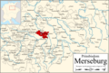 Locator Bishopric of Merseburg - NL.png 1,917 × 1,289; 1,013 KB
-
 Locator Bishopric of Naumburg - NL.png 1,917 × 1,289; 1,012 KB
-
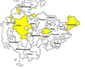
 Locator Upper Saxon Circle.svg 1,165 × 1,140; 193 KB
-
 Map of Thuringia (1680)-DE.svg 1,329 × 1,164; 1.18 MB
-
 Map of Thuringia (1680)-NL.svg 1,329 × 1,164; 1.43 MB
-
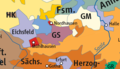 North Thuringia and Harz 1648.png 600 × 346; 85 KB
-
 OpperSaxiseKreits.gif 712 × 589; 314 KB
-
 Pommern-Wolgast.jpg 3,139 × 3,548; 671 KB
-
 Ruppin 1400.png 651 × 434; 89 KB
-
 Sajonia1485.jpg 750 × 463; 82 KB
-
 SajoniaGothaAltenburg.jpg 550 × 450; 51 KB
-
 SajoniaGothaAltenburg.png 550 × 450; 121 KB
-
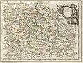
 Saxoniae Superioris Circulus.jpg 7,332 × 6,268; 19.03 MB
-
 Saxony (Division of Leipzig) - DE.png 1,430 × 959; 653 KB
-
 Saxony (Division of Leipzig) - NL.png 2,875 × 1,933; 1.44 MB
-
 Saxony after the Capitulation of Wittenberg (1547) - DE.png 1,428 × 958; 717 KB
-
 Saxony after the Capitulation of Wittenberg (1547) - NL.png 2,875 × 1,933; 1.63 MB
-
 Saxony after the Treaty of Naumburg - DE.png 2,892 × 1,953; 955 KB
-
 Saxony after the Treaty of Naumburg - NL.png 1,928 × 1,302; 862 KB
-
_-_Geographicus_-_UpperSaxony-cary-1799.jpg)


-DE.svg)
-NL.svg)


_-_DE.png)
_-_NL.png)
_-_DE.png)
_-_NL.png)


.jpg)