Category:Maps of municipalities in the district of Thun to 2013
Jump to navigation
Jump to search
Media in category "Maps of municipalities in the district of Thun to 2013"
The following 36 files are in this category, out of 36 total.
-
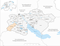
 Karte Gemeinden des Verwaltungskreis Thun 2010.png 1,476 × 1,149; 531 KB
-
 Karte Gemeinde Amsoldingen 2010.png 1,476 × 1,149; 532 KB
-
 Karte Gemeinde Blumenstein 2010.png 1,476 × 1,149; 532 KB
-
 Karte Gemeinde Buchholterberg 2010.png 1,476 × 1,149; 532 KB
-
 Karte Gemeinde Burgistein 2010.png 1,476 × 1,149; 532 KB
-
 Karte Gemeinde Eriz 2010.png 1,476 × 1,149; 533 KB
-
 Karte Gemeinde Fahrni 2010.png 1,476 × 1,149; 532 KB
-
 Karte Gemeinde Forst-Längenbühl 2010.png 1,476 × 1,149; 532 KB
-
 Karte Gemeinde Gurzelen 2010.png 1,476 × 1,149; 532 KB
-
 Karte Gemeinde Heiligenschwendi 2010.png 1,476 × 1,149; 532 KB
-
 Karte Gemeinde Heimberg 2010.png 1,476 × 1,149; 532 KB
-
 Karte Gemeinde Hilterfingen 2010.png 1,476 × 1,149; 531 KB
-
 Karte Gemeinde Homberg 2010.png 1,476 × 1,149; 532 KB
-
 Karte Gemeinde Horrenbach-Buchen 2010.png 1,476 × 1,149; 533 KB
-
 Karte Gemeinde Höfen bei Thun 2010.png 1,476 × 1,149; 532 KB
-
 Karte Gemeinde Kienersrüti 2010.png 1,476 × 1,149; 531 KB
-
 Karte Gemeinde Niederstocken 2010.png 1,476 × 1,149; 532 KB
-
 Karte Gemeinde Oberhofen am Thunersee 2010.png 1,476 × 1,149; 531 KB
-
 Karte Gemeinde Oberlangenegg 2010.png 1,476 × 1,149; 532 KB
-
 Karte Gemeinde Oberstocken 2010.png 1,476 × 1,149; 532 KB
-
 Karte Gemeinde Pohlern 2010.png 1,476 × 1,149; 532 KB
-
 Karte Gemeinde Reutigen 2010.png 1,476 × 1,149; 531 KB
-
 Karte Gemeinde Schwendibach 2010.png 1,476 × 1,149; 531 KB
-
 Karte Gemeinde Seftigen 2010.png 1,476 × 1,149; 532 KB
-
 Karte Gemeinde Sigriswil 2010.png 1,476 × 1,149; 533 KB
-
 Karte Gemeinde Steffisburg 2010.png 1,476 × 1,149; 533 KB
-
 Karte Gemeinde Teuffenthal 2010.png 1,476 × 1,149; 532 KB
-
 Karte Gemeinde Thierachern 2010.png 1,476 × 1,149; 532 KB
-
 Karte Gemeinde Thun 2010.png 1,476 × 1,149; 533 KB
-
 Karte Gemeinde Uebeschi 2010.png 1,476 × 1,149; 532 KB
-
 Karte Gemeinde Uetendorf 2010.png 1,476 × 1,149; 532 KB
-
 Karte Gemeinde Unterlangenegg 2010.png 1,476 × 1,149; 532 KB
-
 Karte Gemeinde Uttigen 2010.png 1,476 × 1,149; 532 KB
-
 Karte Gemeinde Wachseldorn 2010.png 1,476 × 1,149; 531 KB
-
 Karte Gemeinde Wattenwil 2010.png 1,476 × 1,149; 532 KB
-
 Karte Gemeinde Zwieselberg 2010.png 1,476 × 1,149; 531 KB


