Category:Maps of municipalities in the district of Kreuzlingen old
Jump to navigation
Jump to search
Media in category "Maps of municipalities in the district of Kreuzlingen old"
The following 13 files are in this category, out of 13 total.
-
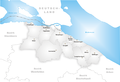
 Karte Gemeinde Altnau.png 1,181 × 805; 201 KB
-
 Karte Gemeinde Bottighofen.png 1,181 × 805; 199 KB
-
 Karte Gemeinde Ermatingen.png 1,181 × 805; 202 KB
-
 Karte Gemeinde Gottlieben.png 1,181 × 805; 197 KB
-
 Karte Gemeinde Güttingen.png 1,181 × 805; 202 KB
-
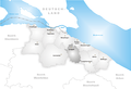
 Karte Gemeinde Kemmental.png 1,181 × 805; 204 KB
-
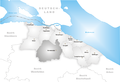
 Karte Gemeinde Kreuzlingen.png 1,181 × 805; 202 KB
-
 Karte Gemeinde Langrickenbach.png 1,181 × 805; 202 KB
-
 Karte Gemeinde Lengwil.png 1,181 × 805; 201 KB
-
 Karte Gemeinde Münsterlingen.png 1,181 × 805; 200 KB
-
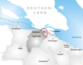 Karte Gemeinde Tägerwilen-Tägermoos.png 650 × 514; 104 KB
-
 Karte Gemeinde Tägerwilen.png 1,181 × 805; 202 KB
-
 Karte Gemeinde Wäldi.png 1,181 × 805; 202 KB


