Category:Maps of Fatu-Hiva
Jump to navigation
Jump to search
Media in category "Maps of Fatu-Hiva"
The following 12 files are in this category, out of 12 total.
-

-
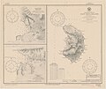 Fatu Hiva 1920 nautical chart.jpg 4,574 × 3,843; 3.5 MB
-
 FATU HIVA.JPG 3,032 × 2,008; 776 KB
-
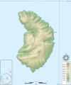
 Fatu-Hiva.png 1,281 × 1,593; 55 KB
-

-
 Fatuhiva.map.svg 585 × 703; 2 KB
-
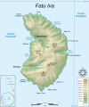
 FatuIva topographic map-blank.svg 750 × 900; 388 KB
-
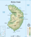
 FatuIva topographic map-fr.svg 750 × 900; 414 KB
-
 FatuIva topographic map-mk.svg 750 × 900; 413 KB
-
 FatuIva topographic map-ru.svg 750 × 900; 414 KB
-
 FatuIva topographic map-uk.png 750 × 900; 244 KB
-

.jpg)


_50_Prozent_verkleinert_(cropped).jpg)


