Category:Locator maps of islands of Tasmania
Jump to navigation
Jump to search
Media in category "Locator maps of islands of Tasmania"
The following 29 files are in this category, out of 29 total.
-
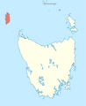
 Australia Tasmania location map Bruny Island.png 835 × 1,024; 88 KB
-
 Australia Tasmania location map Cape Barren Island.png 835 × 1,024; 88 KB
-
 Australia Tasmania location map Clarke Island.png 835 × 1,024; 88 KB
-
 Australia Tasmania location map Flinders Island.png 835 × 1,024; 88 KB
-
 Australia Tasmania location map Hunter Island.png 835 × 1,024; 88 KB
-
 Australia Tasmania location map King Island.png 835 × 1,024; 88 KB
-
 Australia Tasmania location map Maria Island.png 835 × 1,024; 88 KB
-
 Australia Tasmania location map Robbins Island.png 835 × 1,024; 88 KB
-
 Australia Tasmania location map Schouten Island.png 835 × 1,024; 88 KB
-
 Australia Tasmania location map Three Hummock Island.png 835 × 1,024; 88 KB
-
 Curtis Island Map.png 339 × 589; 16 KB
-
 De Witt Island Map.png 1,078 × 626; 60 KB
-
 Hobart locator-MJC.png 563 × 476; 12 KB
-
 Hobart locator.png 563 × 476; 9 KB
-
 Hogan Island map.png 2,042 × 2,011; 164 KB
-
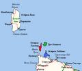
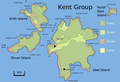 Kent Group map.png 800 × 544; 50 KB
-
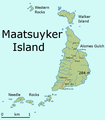 Maatsuyker Island Map.png 601 × 684; 35 KB
-
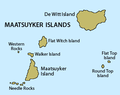 Maatsuyker Islands.png 368 × 292; 8 KB
-
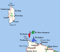
 MaatsuykerGroup.png 368 × 292; 7 KB
-
 Schouten island map - de.png 1,196 × 821; 40 KB
-
 Schouten island map.png 1,196 × 821; 41 KB
-
 Tasmania in Australia map.png 200 × 186; 11 KB
-
 Tasmania in Australia.svg 2,055 × 1,846; 929 KB
-
 Tasmania locator-MJC.png 563 × 476; 12 KB
-
 Tasmania NW Islands fr.png 552 × 479; 16 KB
-
 Tasmania NW Islands ru.png 552 × 479; 16 KB
-
 Tasmania NW Islands.jpg 523 × 468; 29 KB
-
 TasmaniaMap.png 2,190 × 1,577; 151 KB
-
 Tigris-Australia location Tasmania.svg 2,055 × 1,846; 159 KB


