Category:Horn Islands
Jump to navigation
Jump to search
island group  | |||||
| Upload media | |||||
| Instance of |
| ||||
|---|---|---|---|---|---|
| Location | Wallis and Futuna, France | ||||
| Located in or next to body of water | |||||
| Area |
| ||||
| Elevation above sea level |
| ||||
 | |||||
Subcategories
This category has the following 2 subcategories, out of 2 total.
A
F
Media in category "Horn Islands"
The following 23 files are in this category, out of 23 total.
-
 1619 Schouten map close-up (Niuas, Futuna and Alofi islands).jpg 796 × 462; 200 KB
-
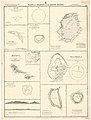 Admiralty Chart No 987 Plans of Islands in the South Pacific, Published 1873.jpg 8,458 × 11,138; 24.75 MB
-
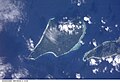 Alofi island NASA ISS002-E-6985.jpg 3,060 × 2,092; 1.47 MB
-
 AMH-8125-KB View of the island of Hoorn in the Pacific Ocean.jpg 1,956 × 2,400; 999 KB
-
 Futuna alofi.jpg 857 × 687; 158 KB
-
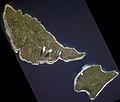 Futuna and Alofi from space (cropped).jpg 884 × 754; 229 KB
-
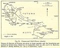
 Futuna and Alofi.jpg 1,011 × 1,395; 823 KB
-
 Futuna i Alofi from space (rotated).jpg 639 × 1,000; 218 KB
-
 Futuna i Alofi from space.jpg 1,000 × 639; 217 KB
-
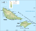
 Futuna location map.svg 969 × 667; 50 KB
-
 Futuna relief location map.png 969 × 667; 173 KB
-
 Futuna Vele satellite picture (cropped).jpg 1,344 × 931; 277 KB
-
 Hoornse Eilanden Futuna en Alofi (rotated).jpg 1,164 × 887; 378 KB
-
 Hoornse Eilanden Futuna en Alofi.jpg 467 × 1,068; 397 KB
-
 Horn Islands cropped from Plans in the South Pacific Ocean 1951 US nautical chart.jpg 2,872 × 2,487; 3.23 MB
-
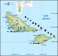 Horn topo map BE.svg 1,000 × 960; 137 KB
-
 LocationHornIslands.PNG 250 × 158; 5 KB
-
 Plans in the South Pacific Ocean 1951 US nautical chart.jpg 6,154 × 8,909; 21.39 MB
-
 Porte dossier lafi futuna.jpg 2,810 × 2,192; 3.74 MB
-
 WF -Hoorn.png 500 × 500; 16 KB
-
 Îles Horn (Wallis-et-Futuna)-de.svg 993 × 848; 81 KB
-
 Îles Horn (Wallis-et-Futuna)-fr.svg 1,020 × 957; 160 KB
-
 Îles Horn (Wallis-et-Futuna)-mk.svg 1,020 × 957; 160 KB
.jpg)


.jpg)

.jpg)


.jpg)
.jpg)


-de.svg)
-fr.svg)
-mk.svg)