Category:Hollym, East Riding of Yorkshire
Jump to navigation
Jump to search
English: Hollym is a small village and civil parish in the East Riding of Yorkshire, England, in an area known as Holderness. It is situated approximately 2 miles (3.2 km) south of Withernsea and is on the A1033 road.
village and civil parish in East Riding of Yorkshire, United Kingdom  | |||||
| Upload media | |||||
| Instance of | |||||
|---|---|---|---|---|---|
| Location | East Riding of Yorkshire, Yorkshire and the Humber, England | ||||
| Population |
| ||||
 | |||||
Subcategories
This category has the following 3 subcategories, out of 3 total.
Media in category "Hollym, East Riding of Yorkshire"
The following 200 files are in this category, out of 217 total.
(previous page) (next page)-
 A footpath heading to the A1033 - geograph.org.uk - 2235572.jpg 800 × 600; 356 KB
-
 A horse's house on Holmpton Road, Hollym - geograph.org.uk - 1055514.jpg 640 × 427; 325 KB
-
 A snow filled drain in Holderness - geograph.org.uk - 2217428.jpg 800 × 600; 285 KB
-
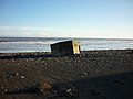 A WW2 Pill Box on the beach (geograph 2200441).jpg 800 × 600; 268 KB
-
 A1033 road at Hollym.jpg 640 × 480; 58 KB
-
 A1033 towards Withernsea - geograph.org.uk - 1931143.jpg 640 × 480; 48 KB
-
 A1033 towards Withernsea - geograph.org.uk - 1931148.jpg 640 × 480; 68 KB
-
 Another one bites the dust - geograph.org.uk - 2200451.jpg 800 × 600; 236 KB
-
 Beach at Hollym.jpg 404 × 640; 277 KB
-
 Beach north of The Runnell - geograph.org.uk - 6055264.jpg 1,600 × 1,200; 237 KB
-
 BEACon Weather Radar - geograph.org.uk - 5524991.jpg 1,024 × 790; 156 KB
-
 Beware of cows on the airfield Hollym (geograph 4582513).jpg 640 × 427; 50 KB
-
 Beware of cows on the airfield Hollym (geograph 4582524).jpg 640 × 427; 54 KB
-
 Boulder clay cliff south of Withernsea (geograph 6054962).jpg 3,461 × 2,585; 1.28 MB
-
 Bracken Hill, Hollym - geograph.org.uk - 280765.jpg 640 × 478; 127 KB
-
 By Smook Hills, near Withernsea - geograph.org.uk - 5296002.jpg 640 × 480; 428 KB
-
 Caravan Park, Withernsea (geograph 5297807).jpg 640 × 473; 372 KB
-
 Church of St. Nicholas, Hollym - geograph.org.uk - 5511150.jpg 1,024 × 768; 196 KB
-

-
 Cliffside farm - geograph.org.uk - 57505.jpg 640 × 480; 122 KB
-
 Clifftop anglers - geograph.org.uk - 5522499.jpg 1,024 × 768; 221 KB
-
 Clifftop near Withernsea (geograph 5522503).jpg 1,024 × 768; 195 KB
-
 Clifftop path - geograph.org.uk - 5522491.jpg 1,024 × 768; 270 KB
-
 Clifftop Path south of Withernsea - geograph.org.uk - 758547.jpg 640 × 348; 160 KB
-

-
 Coastal Erosion - geograph.org.uk - 932261.jpg 640 × 480; 80 KB
-
 Coastal erosion south of Intack farm - geograph.org.uk - 1055483.jpg 640 × 427; 343 KB
-
 Coastal erosion south of Withernsea (geograph 6054927).jpg 1,600 × 1,200; 190 KB
-
 Coastline and cliffs abeam Hollym aerial 2015 (geograph 4582501).jpg 640 × 427; 53 KB
-
 Copse north of Holmpton - geograph.org.uk - 1129407.jpg 640 × 480; 219 KB
-
 Crumbling edge - geograph.org.uk - 5525011.jpg 1,024 × 768; 217 KB
-

-
 Drain alongside Holmpton Road - geograph.org.uk - 5524993.jpg 1,024 × 768; 175 KB
-
 Drain at North Leys - geograph.org.uk - 5892340.jpg 1,600 × 1,065; 856 KB
-
 Eastfield Farm Hollym.jpg 640 × 480; 71 KB
-
 Eastfield Farm, Hollym - geograph.org.uk - 2293410.jpg 800 × 600; 324 KB
-
 Eastfield Farm, Hollym - geograph.org.uk - 2293411.jpg 800 × 600; 249 KB
-
 Eastfield Farm, Hollym - geograph.org.uk - 5892227.jpg 1,600 × 1,065; 453 KB
-

-

-
 End of South Leys Road, Hollym - geograph.org.uk - 6054877.jpg 1,600 × 1,200; 313 KB
-
 Entering Hollym - geograph.org.uk - 6374796.jpg 640 × 480; 75 KB
-
 Farm at Hollym - geograph.org.uk - 5297792.jpg 640 × 480; 449 KB
-
 Farm track near Hollym - geograph.org.uk - 1931145.jpg 640 × 480; 129 KB
-
 Farm track off South Leys Lane - geograph.org.uk - 5870477.jpg 1,024 × 768; 218 KB
-
 Farmland near Hollym - geograph.org.uk - 1931712.jpg 640 × 480; 85 KB
-
 Farmland near Hollym - geograph.org.uk - 45970.jpg 640 × 480; 95 KB
-
 Farmland Pond - geograph.org.uk - 876790.jpg 640 × 480; 99 KB
-
 Farmland, Nevilles Farm - geograph.org.uk - 1931720.jpg 640 × 480; 67 KB
-
 Field drain in the cliff - geograph.org.uk - 6055261.jpg 1,600 × 1,200; 470 KB
-
 Field edge track at Scarborough Hill - geograph.org.uk - 4776850.jpg 4,000 × 3,000; 2.79 MB
-
 Fingerpost at Railway Cottages, Croft Lane, Hollym - geograph.org.uk - 5890404.jpg 1,600 × 1,065; 611 KB
-
 Footbridge near Holmpton - geograph.org.uk - 1129403.jpg 450 × 640; 171 KB
-
 Footbridge on footpath to Holmpton Beach - geograph.org.uk - 1129409.jpg 480 × 640; 112 KB
-
 Footbridge over Winestead Drain - geograph.org.uk - 5890379.jpg 1,600 × 1,065; 623 KB
-
 Footbridge over Winestead Drain - geograph.org.uk - 5890384.jpg 1,600 × 1,065; 720 KB
-
 Footpath through the Field - geograph.org.uk - 876805.jpg 640 × 480; 130 KB
-
 Footpath through the Field - geograph.org.uk - 876811.jpg 480 × 640; 118 KB
-
 Footpath to Hollym - geograph.org.uk - 5297764.jpg 640 × 861; 745 KB
-
 Footpath to Nevills Bridge - geograph.org.uk - 5870482.jpg 1,024 × 768; 238 KB
-
 Footpath towards Crofts Lane, Hollym - geograph.org.uk - 5890393.jpg 1,600 × 1,065; 542 KB
-
 Garth Pheasantry, Crofts Lane, Hollym - geograph.org.uk - 5890734.jpg 1,600 × 1,065; 534 KB
-
 Heading towards Wakefield Lane - geograph.org.uk - 2217425.jpg 800 × 600; 264 KB
-
 Here now, going later^ - geograph.org.uk - 1129756.jpg 640 × 326; 38 KB
-
 Here today, gone tomorrow - geograph.org.uk - 1055542.jpg 640 × 415; 332 KB
-
 High water mark in the snow - geograph.org.uk - 2200466.jpg 800 × 600; 302 KB
-
 Holderness coastline near Hollym - geograph.org.uk - 4586962.jpg 640 × 427; 51 KB
-
 Holderness Farmland - geograph.org.uk - 1131036.jpg 527 × 640; 131 KB
-
 Holiday Chalets - geograph.org.uk - 1050934.jpg 640 × 427; 390 KB
-
 Hollym - geograph.org.uk - 294451.jpg 640 × 401; 68 KB
-
 Hollym Airfield (geograph 2406990).jpg 3,648 × 2,736; 1.72 MB
-

-

-
 Hollym Carrs Nature Reserve - geograph.org.uk - 280936.jpg 640 × 480; 108 KB
-
 Hollym Hogs.jpg 422 × 640; 98 KB
-
 Hollym House Farm, Northside Road, Hollym - geograph.org.uk - 5890738.jpg 1,600 × 1,065; 724 KB
-
 Hollym House Farm, Northside Road, Hollym - geograph.org.uk - 5890744.jpg 1,600 × 1,065; 563 KB
-
 Hollym Road, Hollym - geograph.org.uk - 5892224.jpg 1,600 × 1,065; 723 KB
-
 Hollym Village Hall - geograph.org.uk - 4984189.jpg 5,184 × 3,888; 6.07 MB
-
 Hollym Village Hall - geograph.org.uk - 6374801.jpg 800 × 516; 79 KB
-
 Hollym village sign - geograph.org.uk - 2293414.jpg 800 × 600; 337 KB
-
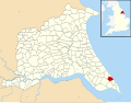 Hollym, East Riding of Yorkshire UK parish locator map.svg 1,425 × 1,107; 1.68 MB
-
 Hollym, Intack reborn - geograph.org.uk - 4586747.jpg 640 × 427; 76 KB
-
 Hollym, into the void - geograph.org.uk - 4586768.jpg 640 × 427; 57 KB
-
 Holme Farm, Hollym - geograph.org.uk - 5890751.jpg 1,600 × 1,065; 567 KB
-
 Holmpton Road - geograph.org.uk - 234159.jpg 480 × 640; 75 KB
-
 Holmpton Road Sewage Works - geograph.org.uk - 293375.jpg 640 × 451; 91 KB
-
 Holmpton Road towards Withernsea - geograph.org.uk - 6374806.jpg 800 × 600; 99 KB
-
 Holmpton Road, near Withernsea (geograph 5295999).jpg 640 × 467; 396 KB
-

-
 Houses on North Leys Road - geograph.org.uk - 6374804.jpg 800 × 544; 74 KB
-
 Houses on Northside Road, Hollym - geograph.org.uk - 5890749.jpg 1,600 × 1,065; 594 KB
-
 Houses on Withernsea Road, Hollym - geograph.org.uk - 6373532.jpg 4,984 × 3,421; 4.73 MB
-
 Intack Farm - geograph.org.uk - 1048412.jpg 640 × 427; 266 KB
-
 Intack Farm - geograph.org.uk - 2034773.jpg 1,600 × 1,042; 393 KB
-
 Intack Farm - geograph.org.uk - 998923.jpg 640 × 369; 152 KB
-
 Intack Farm, Hollym - geograph.org.uk - 200435.jpg 640 × 493; 107 KB
-
 Intack on Holmpton Road - geograph.org.uk - 5522505.jpg 1,024 × 768; 125 KB
-
 Intack, December 2006 - geograph.org.uk - 293374.jpg 640 × 474; 97 KB
-
 Large rock in the boulder clay - geograph.org.uk - 6055270.jpg 1,600 × 1,200; 453 KB
-
 Lighthouse ahead^ - geograph.org.uk - 57513.jpg 640 × 480; 116 KB
-

-
 Llamas at Nevilles Farm - geograph.org.uk - 1055520.jpg 640 × 427; 375 KB
-
 Lobster pot and field drain - geograph.org.uk - 6055291.jpg 1,600 × 1,200; 305 KB
-
 Lobster pot on the beach - geograph.org.uk - 6055293.jpg 1,600 × 1,200; 176 KB
-
 Lobster pots on the beach - geograph.org.uk - 6055280.jpg 1,600 × 1,199; 186 KB
-
 Looking back to Withernsea - geograph.org.uk - 876787.jpg 640 × 480; 104 KB
-
 Looking towards Hollym (geograph 2259132).jpg 800 × 600; 303 KB
-
 Looking towards Withernsea - geograph.org.uk - 57511.jpg 640 × 480; 142 KB
-
 Manor Farm, Hollym - geograph.org.uk - 294455.jpg 640 × 467; 107 KB
-
 Manor Farm, Hollym - geograph.org.uk - 5870529.jpg 1,024 × 768; 197 KB
-
 Mill Lane, Hollym, East Yorkshire - geograph.org.uk - 2293407.jpg 800 × 600; 316 KB
-
 Minor Track - geograph.org.uk - 57388.jpg 640 × 480; 99 KB
-
 Myer's Lane, Hollym - geograph.org.uk - 294470.jpg 640 × 476; 113 KB
-
 Nevilles Farm Hollym.jpg 640 × 480; 54 KB
-
 Nevilles Farm, Hollym - geograph.org.uk - 1048541.jpg 640 × 441; 448 KB
-
 Nevilles Farm, Hollym - geograph.org.uk - 1931716.jpg 640 × 404; 43 KB
-
 Nevilles Farm, Hollym - geograph.org.uk - 293379.jpg 640 × 456; 53 KB
-
 New Farm on the A1033 Hollym Road - geograph.org.uk - 2217411.jpg 800 × 600; 300 KB
-
 North Carr Dales (geograph 1931708).jpg 640 × 480; 88 KB
-
 North Carr Dales - geograph.org.uk - 1931696.jpg 640 × 480; 88 KB
-
 North Carr Dales Farm - geograph.org.uk - 1931702.jpg 640 × 480; 77 KB
-
 North Carr Dales Road - geograph.org.uk - 1931698.jpg 640 × 480; 132 KB
-
 North Carr Dales Road - geograph.org.uk - 234897.jpg 640 × 480; 165 KB
-
 North Carr Dales Road - geograph.org.uk - 6365648.jpg 1,024 × 768; 308 KB
-
 North Carr Dales Road, Hollym - geograph.org.uk - 294449.jpg 478 × 640; 153 KB
-
 North Carr Dales Road, Hollym - geograph.org.uk - 5298286.jpg 640 × 480; 441 KB
-
 North Carr Dales, Hollym - geograph.org.uk - 294445.jpg 477 × 640; 100 KB
-
 North Leys - geograph.org.uk - 6054906.jpg 1,600 × 1,200; 553 KB
-
 North Leys Road heading east - geograph.org.uk - 1931713.jpg 640 × 480; 69 KB
-
 North Leys Road leaving Hollym - geograph.org.uk - 6374802.jpg 800 × 600; 95 KB
-
 North Leys Road, Hollym - geograph.org.uk - 2145894.jpg 800 × 600; 231 KB
-
 North Leys Road, Hollym - geograph.org.uk - 6372774.jpg 5,184 × 3,888; 5.16 MB
-
 North Leys Road, Hollym - geograph.org.uk - 6372776.jpg 5,045 × 3,373; 5.28 MB
-
 Northside Road Hollym.jpg 523 × 640; 184 KB
-
 Northside Road in Hollym - geograph.org.uk - 1042887.jpg 640 × 480; 153 KB
-
 Northside Road, Hollym - geograph.org.uk - 5890746.jpg 1,600 × 1,065; 572 KB
-
 Northside Road, Hollym - geograph.org.uk - 5892178.jpg 1,600 × 1,065; 639 KB
-
 Northside Road, Hollym - geograph.org.uk - 5892219.jpg 1,600 × 1,065; 480 KB
-

-
 Pasture, and cliffs north of Holmpton - geograph.org.uk - 1048578.jpg 640 × 427; 365 KB
-
 Path leading to Withernsea Road north of Holmpton - geograph.org.uk - 5892305.jpg 1,600 × 1,065; 807 KB
-
 Path leading to Withernsea Road north of Holmpton - geograph.org.uk - 5892309.jpg 1,600 × 1,065; 623 KB
-
 Path leading to Withernsea Road north of Holmpton - geograph.org.uk - 5892315.jpg 1,600 × 1,065; 398 KB
-
 Path leading to Withernsea Road north of Holmpton - geograph.org.uk - 5892343.jpg 1,600 × 1,065; 1.1 MB
-
 Pillbox at The Runnell, Holmpton - geograph.org.uk - 5894551.jpg 1,600 × 1,065; 789 KB
-
 Pillbox on beach (geograph 6054919).jpg 1,600 × 1,260; 218 KB
-
 Pillbox on the beach (geograph 6054922).jpg 1,600 × 1,200; 206 KB
-
 Pillbox on the beach near Hollym (geograph 4586979).jpg 640 × 427; 54 KB
-
 Plough Inn, Hollym - geograph.org.uk - 5297812.jpg 640 × 541; 396 KB
-
 Pond near North Carr Dales Farm (geograph 1931704).jpg 640 × 480; 95 KB
-
 Radar dome near Hollym - geograph.org.uk - 5296079.jpg 509 × 640; 411 KB
-
 Red House Farm - geograph.org.uk - 1048408.jpg 640 × 427; 301 KB
-
 Red House on Holmpton Road (geograph 6374808).jpg 800 × 600; 115 KB
-
 Road junction at Eastfield Farm - geograph.org.uk - 4776857.jpg 4,000 × 3,000; 3.86 MB
-
 Scrubland - geograph.org.uk - 57534.jpg 640 × 480; 134 KB
-
 Scruff's gorse bush, Hollym Carrs - geograph.org.uk - 761417.jpg 640 × 480; 115 KB
-

-
 Secluded field - geograph.org.uk - 57510.jpg 640 × 480; 135 KB
-
 Sewage outflow protection - geograph.org.uk - 6054911.jpg 1,600 × 1,200; 244 KB
-
 Sewage works on Holmpton Road - geograph.org.uk - 6374807.jpg 800 × 486; 89 KB
-
 South Carr Dales Road at Hollym - geograph.org.uk - 1042860.jpg 640 × 480; 186 KB
-
 South Carr Dales Road, Hollym - geograph.org.uk - 294446.jpg 640 × 408; 69 KB
-
 South Carr Dales, Hollym - geograph.org.uk - 280749.jpg 640 × 486; 91 KB
-
 South Field, Hollym - geograph.org.uk - 294465.jpg 640 × 477; 145 KB
-
 South Field, Hollym - geograph.org.uk - 5856098.jpg 1,024 × 768; 125 KB
-
 South Leys - geograph.org.uk - 5870487.jpg 1,024 × 768; 199 KB
-
 South Leys Road near Eastfield Farm, Hollym - geograph.org.uk - 5892226.jpg 1,600 × 1,065; 523 KB
-
 South Leys Road, Hollym - geograph.org.uk - 1931709.jpg 640 × 480; 94 KB
-
 South Leys Road, Hollym - geograph.org.uk - 2293405.jpg 800 × 600; 253 KB
-
 South Leys Road, Hollym - geograph.org.uk - 294456.jpg 640 × 479; 132 KB
-
 South Leys Road, Hollym - geograph.org.uk - 5892231.jpg 1,600 × 1,065; 819 KB
-

-
 St Nicholas Church, Hollym - geograph.org.uk - 5892223.jpg 1,600 × 1,065; 902 KB
-
 St Nicholas's Church, Hollym - geograph.org.uk - 6374797.jpg 800 × 644; 143 KB
-
 Straw Bales in the Sun - geograph.org.uk - 1042896.jpg 480 × 640; 144 KB
-

-
 The 'Footpath' to Hollym - geograph.org.uk - 1042918.jpg 640 × 480; 70 KB
-
 The A1033 road into Hollym.jpg 640 × 480; 82 KB
-

-
 The Beach at Hollym - geograph.org.uk - 537959.jpg 640 × 480; 69 KB
-
 The beach north of Holmpton - geograph.org.uk - 1129417.jpg 640 × 480; 107 KB
-
 The cliffs at Hollym - geograph.org.uk - 293373.jpg 640 × 445; 82 KB
-
 The coast south of Withernsea - geograph.org.uk - 5297232.jpg 5,878 × 3,918; 5.17 MB
-
 The footpath from Hollym to Holmpton - geograph.org.uk - 1129394.jpg 480 × 640; 73 KB
-
 The footpath from Holmpton to Hollym - geograph.org.uk - 1129390.jpg 480 × 640; 143 KB
-
 The footpath is marked on this side of the hedge (geograph 6365654).jpg 1,024 × 768; 211 KB
-
 The former railway to Withernsea - geograph.org.uk - 5511140.jpg 1,024 × 768; 182 KB
-
 The Path to Intack Farm - geograph.org.uk - 758563.jpg 640 × 338; 144 KB
-
 The Plough Inn, Hollym - geograph.org.uk - 1931154.jpg 640 × 480; 59 KB
-
 The Plough Inn, Hollym - geograph.org.uk - 5892221.jpg 1,600 × 1,065; 631 KB
-
 The Plough Inn, Hollym - geograph.org.uk - 6374799.jpg 640 × 416; 55 KB
-
 The Railway Cottages (geograph 2145883).jpg 800 × 600; 250 KB
-
 The road to Withernsea - geograph.org.uk - 57529.jpg 640 × 480; 93 KB
-
 The Runnell on the East Yorkshire coast - geograph.org.uk - 2200471.jpg 800 × 600; 281 KB
-

-
 The southern end of the construction site (geograph 6869400).jpg 1,024 × 768; 214 KB
-
 The way to Toffling Farm near Patrington - geograph.org.uk - 2236564.jpg 800 × 600; 200 KB
-
 Track on Hollym Carrs Nature Reserve - geograph.org.uk - 5863211.jpg 1,024 × 768; 198 KB
-
 Track to Toffling Farm - geograph.org.uk - 1931139.jpg 640 × 480; 75 KB


.jpg)


.jpg)
.jpg)
.jpg)


.jpg)


.jpg)


.jpg)


.jpg)
.jpg)


.jpg)


.jpg)


.jpg)


.jpg)


.jpg)


.jpg)
.jpg)
.jpg)

.jpg)


.jpg)


.jpg)


.jpg)


.jpg)


