Category:Holländermühle Kolpien
Jump to navigation
Jump to search
| Object location | | View all coordinates using: OpenStreetMap |
|---|
This is the category of the Brandenburger Baudenkmal (cultural heritage monument) with the ID 09105498 (Wikidata)
|
| Upload media | |||||
| Instance of | |||||
|---|---|---|---|---|---|
| Location |
| ||||
| Heritage designation | |||||
 | |||||
Media in category "Holländermühle Kolpien"
The following 10 files are in this category, out of 10 total.
-
 Fotothek df rp-b 0790058 Dahme-Mark-Schöna-Kolpien. Wallholländer.jpg 505 × 820; 133 KB
-
 Fotothek df rp-b 0790060 Dahme-Mark-Schöna-Kolpien. Wallholländer.jpg 800 × 505; 136 KB
-
 Fotothek df rp-b 0790062 Dahme-Mark-Schöna-Kolpien. Wallholländer.jpg 504 × 820; 134 KB
-

-

-

-
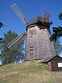
 Holländerwindmühle Kolpien 2.jpg 2,576 × 1,932; 955 KB
-
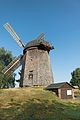
 Holländerwindmühle Kolpien.jpg 1,932 × 2,576; 1.46 MB
-
 Schoena-Kolpien Windmuehle.jpg 4,000 × 5,600; 1.73 MB
-
 Schoena-Kolpien Windmuehle1.jpg 3,265 × 4,897; 1.67 MB


