Category:Havenstraat 16, Oudewater
Jump to navigation
Jump to search
| Object location | | View all coordinates using: OpenStreetMap |
|---|
 | |||||
| Upload media | |||||
| Instance of |
| ||||
|---|---|---|---|---|---|
| Location | Oudewater, Utrecht, Netherlands | ||||
| Street address |
| ||||
| Located on street |
| ||||
| Heritage designation |
| ||||
 | |||||
|
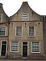
This is a category about rijksmonument number 32025
|
| Address |
|
Media in category "Havenstraat 16, Oudewater"
The following 9 files are in this category, out of 9 total.
-
 3421 Oudewater, Netherlands - panoramio (106).jpg 4,896 × 3,264; 2.46 MB
-
 3421 Oudewater, Netherlands - panoramio (12).jpg 2,048 × 1,148; 553 KB
-
 3421 Oudewater, Netherlands - panoramio (28).jpg 2,048 × 1,148; 464 KB
-
 3421 Oudewater, Netherlands - panoramio (37).jpg 2,048 × 1,148; 528 KB
-
 Overzicht met nummer 14 van de Havenstraat - Oudewater - 20179834 - RCE.jpg 1,200 × 943; 218 KB
-
 RM32025 Oudewater - Havenstraat 16.jpg 1,944 × 2,592; 1.33 MB
-
 Voorgevel - Oudewater - 20179872 - RCE.jpg 812 × 1,200; 220 KB
-
 Voorgevels - Oudewater - 20179873 - RCE.jpg 1,200 × 950; 254 KB
-
 Voorgevels - Oudewater - 20179874 - RCE.jpg 950 × 1,200; 257 KB
.jpg)
.jpg)
.jpg)
.jpg)


