Category:Halsham
Jump to navigation
Jump to search
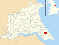
English: Halsham is a village and civil parish in the East Riding of Yorkshire, England, in an area known as Holderness. It is situated approximately 4 miles (6.4 km) west of Withernsea town centre and it lies south of the B1362 road.
village and civil parish in East Riding of Yorkshire, United Kingdom  | |||||
| Upload media | |||||
| Instance of | |||||
|---|---|---|---|---|---|
| Location | East Riding of Yorkshire, Yorkshire and the Humber, England | ||||
| Population |
| ||||
| Said to be the same as | Halsham (Wikimedia duplicated page, civil parish) | ||||
 | |||||
Subcategories
This category has the following 2 subcategories, out of 2 total.
A
- All Saints Church, Halsham (3 F)
C
- Constable Mausoleum (4 F)
Media in category "Halsham"
The following 200 files are in this category, out of 200 total.
-
 "Engine Corner", Keyingham Drain - geograph.org.uk - 186285.jpg 640 × 480; 123 KB
-
 'V' Field - geograph.org.uk - 2406389.jpg 2,789 × 1,884; 1.44 MB
-
 A bend in the road - geograph.org.uk - 28887.jpg 640 × 480; 97 KB
-
 A farm shop at Mill Farm, Halsham - geograph.org.uk - 2145542.jpg 800 × 600; 300 KB
-
 A Pub No More - geograph.org.uk - 2675288.jpg 3,264 × 2,448; 1.48 MB
-
 A Terrace in East End - geograph.org.uk - 2908124.jpg 3,264 × 2,448; 1.75 MB
-
 Across Roos Drain, near Halsham - geograph.org.uk - 1768041.jpg 640 × 466; 174 KB
-
 All Saints Church, Halsham - geograph.org.uk - 5078524.jpg 640 × 426; 184 KB
-
 Avenue of Trees - geograph.org.uk - 2675195.jpg 3,264 × 2,448; 2.55 MB
-
 B1362 towards Burstwick - geograph.org.uk - 1894487.jpg 640 × 480; 59 KB
-
 B1362 towards Burstwick - geograph.org.uk - 1894573.jpg 640 × 480; 84 KB
-
 B1362 towards Burstwick - geograph.org.uk - 1894623.jpg 640 × 480; 92 KB
-
 B1362 towards Burstwick - geograph.org.uk - 1894633.jpg 640 × 480; 88 KB
-

-
 Badger Lane - geograph.org.uk - 285955.jpg 640 × 481; 101 KB
-
 Badger Lane - geograph.org.uk - 876833.jpg 640 × 480; 105 KB
-
 Black Bank near Eastholme Bridge - geograph.org.uk - 279008.jpg 473 × 640; 116 KB
-
 Black Bank, near Halsham - geograph.org.uk - 5078354.jpg 640 × 480; 168 KB
-
 Bored with large scale plumbing^ - geograph.org.uk - 879425.jpg 640 × 480; 88 KB
-
 Bridleway and Halsham Drain - geograph.org.uk - 4331455.jpg 1,024 × 768; 164 KB
-
 Bridleway at Halsham Carrs - geograph.org.uk - 6622172.jpg 1,600 × 1,075; 668 KB
-

-
 Bridleway by Halsham Drain - geograph.org.uk - 5078362.jpg 480 × 640; 156 KB
-
 Bridleway next to Fox Covert - geograph.org.uk - 3411418.jpg 4,592 × 3,448; 6.32 MB
-
 Bridleway towards Geyhorn Bridge - geograph.org.uk - 6549387.jpg 1,600 × 1,065; 579 KB
-
 Bridleway towards Geyhorn Bridge - geograph.org.uk - 6549390.jpg 1,600 × 1,065; 635 KB
-
 Bridleway towards Geyhorn Bridge - geograph.org.uk - 6549393.jpg 1,600 × 1,065; 588 KB
-
 Bridleway towards Geyhorn Bridge - geograph.org.uk - 6549395.jpg 1,600 × 1,065; 548 KB
-
 Bridleway towards Geyhorn Bridge - geograph.org.uk - 6622134.jpg 1,600 × 1,103; 738 KB
-
 Bull at Eastfield Farm near Halsham - geograph.org.uk - 6622301.jpg 1,600 × 1,600; 645 KB
-
 Bunkers Hill, Halsham - geograph.org.uk - 319604.jpg 640 × 480; 104 KB
-
-
 Causeway Ings Lane (B1362) - geograph.org.uk - 6372944.jpg 800 × 530; 73 KB
-
 Causeway Ings Lane at Halsham - geograph.org.uk - 2213172.jpg 800 × 600; 178 KB
-
 Causeway Ings, Halsham - geograph.org.uk - 717837.jpg 480 × 640; 116 KB
-
 Chantry Lane - the road to Rimswell - geograph.org.uk - 876828.jpg 640 × 480; 91 KB
-
 Chantry Lane towards Winestead - geograph.org.uk - 1894466.jpg 640 × 480; 56 KB
-
 Chantry Lane towards Winestead - geograph.org.uk - 2064900.jpg 800 × 600; 192 KB
-
-
 Chimney Field Road near High Wood - geograph.org.uk - 2145752.jpg 800 × 600; 264 KB
-
 Chimney Field Road, East End, Halsham - geograph.org.uk - 6372708.jpg 4,155 × 3,058; 3.49 MB
-
 Chimney Field Road, East End, Halsham - geograph.org.uk - 6372709.jpg 5,184 × 3,888; 4.27 MB
-
 Chimney Fields Road approaching the junction with North Road - geograph.org.uk - 2913531.jpg 3,264 × 2,448; 1.48 MB
-
 Churchlands Farm from Winestead Lane - geograph.org.uk - 21747.jpg 640 × 480; 91 KB
-
-
 Converted Chapel, Halsham - geograph.org.uk - 1894618.jpg 640 × 480; 85 KB
-
 Cote House Farm, Halsham - geograph.org.uk - 327386.jpg 640 × 445; 87 KB
-
 Cows at Eastfield Farm near Halsham - geograph.org.uk - 6622309.jpg 1,600 × 1,065; 850 KB
-
 Cows at Eastfield Farm near Halsham - geograph.org.uk - 6622310.jpg 1,600 × 1,065; 738 KB
-
 Dalton Lane, Halsham - geograph.org.uk - 2145547.jpg 800 × 600; 335 KB
-
 Dalton Lane, Halsham - geograph.org.uk - 327354.jpg 640 × 450; 81 KB
-
 Derelict building on North Road near Bunker's Hill - geograph.org.uk - 6622223.jpg 1,600 × 1,065; 1,010 KB
-
 Destroyed footbridge - geograph.org.uk - 6503127.jpg 1,024 × 768; 225 KB
-
 East along Southside Road, Halsham - geograph.org.uk - 2145560.jpg 800 × 600; 367 KB
-
 East End, Halsham - geograph.org.uk - 1736536.jpg 640 × 426; 216 KB
-
 East Field Farm, Halsham - geograph.org.uk - 327357.jpg 640 × 406; 65 KB
-
 East Field Farm, Halsham - geograph.org.uk - 327358.jpg 640 × 438; 57 KB
-
 Eastfield Farm off Southside Road, near Halsham - geograph.org.uk - 6623057.jpg 1,600 × 1,054; 657 KB
-
 Eastfield Farm Residential Home, Halsham - geograph.org.uk - 2145569.jpg 800 × 600; 228 KB
-
 Eastholme Bridge - geograph.org.uk - 4331448.jpg 1,024 × 768; 204 KB
-
 Eastholme Bridge - geograph.org.uk - 717825.jpg 640 × 459; 97 KB
-
 Eastholme Bridge, near Halsham - geograph.org.uk - 5078501.jpg 640 × 480; 172 KB
-

-

-
 Entering Halsham - geograph.org.uk - 6372951.jpg 800 × 600; 118 KB
-
 Entrance to Hill Top Farm - geograph.org.uk - 6622219.jpg 1,600 × 1,065; 785 KB
-
 Farm bridge over Halsham Drain - geograph.org.uk - 6549397.jpg 1,600 × 1,065; 743 KB
-
 Farm building-residential home - geograph.org.uk - 28892.jpg 640 × 480; 86 KB
-
 Farm shop, Halsham - geograph.org.uk - 6372962.jpg 640 × 437; 100 KB
-
 Farmland looking towards Fox Covert - geograph.org.uk - 1894515.jpg 640 × 480; 77 KB
-
 Farmland view - geograph.org.uk - 28840.jpg 640 × 454; 86 KB
-
 Field Drain - geograph.org.uk - 3411407.jpg 3,448 × 4,592; 7.01 MB
-
 Field entrance of the B1362 - geograph.org.uk - 1894640.jpg 640 × 480; 104 KB
-
 Fingerpost on Causeway Ings Lane - geograph.org.uk - 6549353.jpg 1,600 × 1,065; 642 KB
-
 Footbridge south of Bunker's Hill - geograph.org.uk - 6622229.jpg 1,600 × 1,116; 1.16 MB
-
 Footpath alongside Roos Drain - geograph.org.uk - 2682631.jpg 3,264 × 2,448; 1.9 MB
-
 Footpath and Field Edge next to Halsham Drain - geograph.org.uk - 2195993.jpg 3,450 × 2,496; 2.29 MB
-
 Footpath at Halsham Carrs - geograph.org.uk - 6622185.jpg 1,600 × 1,064; 651 KB
-
 Footpath at Halsham Carrs - geograph.org.uk - 6622197.jpg 1,600 × 1,054; 736 KB
-

-
 Footpath junction near Halsham - geograph.org.uk - 1767424.jpg 484 × 640; 185 KB
-
 Footpath to Fox Covert - geograph.org.uk - 2682673.jpg 3,264 × 2,448; 1.95 MB
-
 Footpath to Roos Drain - geograph.org.uk - 2682649.jpg 3,264 × 2,448; 1.84 MB
-
 Former Methodist Chapel on North Road the B1362 - geograph.org.uk - 6622214.jpg 1,600 × 1,600; 1,018 KB
-

-
 Fox Covert, Halsham - geograph.org.uk - 327392.jpg 640 × 474; 84 KB
-
 Geyhorn Bridge and the new Roos Wind Farm - geograph.org.uk - 3383605.jpg 3,175 × 2,231; 1.65 MB
-
 Geyhorn Bridge, Burton Pidsea - geograph.org.uk - 269571.jpg 640 × 462; 179 KB
-
 Geyhorn Bridge, Halsham Drain - geograph.org.uk - 6503139.jpg 1,024 × 768; 188 KB
-
 Geyhorn Bridge, near Halsham - geograph.org.uk - 1768038.jpg 640 × 456; 212 KB
-
 Grazing towards Carr House Farm - geograph.org.uk - 6372965.jpg 800 × 551; 98 KB
-
 Green Acre Farm - geograph.org.uk - 5832323.jpg 1,024 × 768; 173 KB
-
 Growing at Last^ - geograph.org.uk - 3411432.jpg 3,448 × 4,592; 6 MB
-
 Halsham - geograph.org.uk - 28839.jpg 640 × 480; 98 KB
-
 Halsham - geograph.org.uk - 6371893.jpg 5,148 × 3,530; 6.13 MB
-
 Halsham Carrs - geograph.org.uk - 1767635.jpg 640 × 426; 188 KB
-
 Halsham Church Hall - geograph.org.uk - 3204235.jpg 1,024 × 768; 327 KB
-
 Halsham Drain - geograph.org.uk - 1894645.jpg 640 × 480; 87 KB
-
 Halsham Drain - geograph.org.uk - 5078386.jpg 640 × 509; 176 KB
-
 Halsham Drain - geograph.org.uk - 6372941.jpg 800 × 600; 99 KB
-
 Halsham Drain - geograph.org.uk - 6503136.jpg 1,024 × 768; 153 KB
-
 Halsham Drain in the late afternoon sun - geograph.org.uk - 3383599.jpg 3,648 × 2,282; 2.29 MB
-
 Halsham Drain in the Snow - geograph.org.uk - 2195995.jpg 640 × 480; 69 KB
-
 Halsham Drain towards Geyhorn Bridge - geograph.org.uk - 6622018.jpg 1,600 × 1,065; 728 KB
-
 Halsham footpath - geograph.org.uk - 1767648.jpg 485 × 640; 203 KB
-
 Halsham Grange - geograph.org.uk - 319603.jpg 640 × 454; 91 KB
-
 Halsham Grange - geograph.org.uk - 474255.jpg 640 × 480; 112 KB
-
 Halsham Grange Cottages - geograph.org.uk - 717814.jpg 640 × 440; 84 KB
-
 Halsham Grange Farm - geograph.org.uk - 6372953.jpg 800 × 429; 84 KB
-
 Halsham House on North Road, West End - geograph.org.uk - 2745914.jpg 800 × 600; 156 KB
-
 Halsham House, School to B^B - geograph.org.uk - 2675244.jpg 3,264 × 2,448; 2.9 MB
-
 Halsham House.jpg 461 × 640; 106 KB
-
 Halsham Mausoleum at Dusk - geograph.org.uk - 3519959.jpg 3,286 × 2,547; 1.49 MB
-
 Halsham road junction. - geograph.org.uk - 23540.jpg 640 × 480; 115 KB
-
 Halsham UK parish locator map.svg 1,425 × 1,107; 1.68 MB
-
 Halsham Village - geograph.org.uk - 23548.jpg 640 × 480; 112 KB
-
 Harvested field near Elm Tree Farm, Halsham - geograph.org.uk - 5512276.jpg 1,024 × 768; 137 KB
-

-

-
 Hill Farm from a high point on Halsham Carrs - geograph.org.uk - 2678213.jpg 3,264 × 2,448; 1.89 MB
-

-
 House on Southside Road, Halsham - geograph.org.uk - 6623062.jpg 1,600 × 1,065; 993 KB
-

-
 K6 telephone box on Dalton Lane, Halsham - geograph.org.uk - 6372961.jpg 594 × 800; 126 KB
-
 Keyingham Drain towards Eastholme Bridge - geograph.org.uk - 6547475.jpg 1,600 × 1,065; 511 KB
-
 Land drains near Halsham - geograph.org.uk - 1733463.jpg 426 × 640; 209 KB
-
 Lone beech tree on Halsham Drain - geograph.org.uk - 264587.jpg 640 × 480; 90 KB
-
 Looking towards Black Bank - geograph.org.uk - 4331450.jpg 1,024 × 768; 208 KB
-
 Mausoleum in the wheat, Halsham - geograph.org.uk - 5077983.jpg 508 × 640; 283 KB
-
 Minor road towards Churchlands Farm - geograph.org.uk - 1930992.jpg 640 × 480; 63 KB
-
 Minor road towards Roos - geograph.org.uk - 1894493.jpg 640 × 480; 96 KB
-
 Minor road towards Roos - geograph.org.uk - 1894510.jpg 640 × 480; 93 KB
-
 Minor road. - geograph.org.uk - 28891.jpg 640 × 480; 74 KB
-
 North End Road, Halsham - geograph.org.uk - 5785180.jpg 2,592 × 1,944; 1.5 MB
-
 Northeast of Halsham - geograph.org.uk - 327388.jpg 640 × 462; 132 KB
-
 Old Hall near Halsham - geograph.org.uk - 1930936.jpg 640 × 480; 116 KB
-
 Old Methodist Chapel Halsham.jpg 640 × 468; 89 KB
-
 On the road to Roos Bridge and Craikham Hill - geograph.org.uk - 4982616.jpg 5,184 × 3,888; 7.41 MB
-
 Over Fields to Carr Farm - geograph.org.uk - 2682657.jpg 3,264 × 2,448; 2.12 MB
-
 Pastures fish pond near Halsham - geograph.org.uk - 2745927.jpg 800 × 600; 87 KB
-
 Pastures fish pond near Halsham - geograph.org.uk - 2745929.jpg 800 × 600; 84 KB
-
 Poplar Farm, Halsham - geograph.org.uk - 327385.jpg 474 × 640; 125 KB
-
 Power to Withernsea - geograph.org.uk - 3411472.jpg 4,036 × 3,059; 2.48 MB
-
 Prepared field at Winestead - geograph.org.uk - 5863179.jpg 1,024 × 768; 146 KB
-
 Public Footpath - geograph.org.uk - 878642.jpg 640 × 480; 115 KB
-
 Public Right of Way - geograph.org.uk - 2406392.jpg 4,032 × 3,024; 1.24 MB
-
 Rape field near Bunker's Hill - geograph.org.uk - 1894577.jpg 640 × 480; 104 KB
-
 Rape field near East Elms - geograph.org.uk - 1894498.jpg 640 × 480; 89 KB
-
 Rimswell Water Tower - geograph.org.uk - 1894463.jpg 640 × 491; 53 KB
-
 Roos Bridge - geograph.org.uk - 1766539.jpg 640 × 443; 226 KB
-
 Roos Drain and Footpath - geograph.org.uk - 2682642.jpg 3,264 × 2,448; 2.63 MB
-
 Roos Drain and Road Bridge - geograph.org.uk - 2682589.jpg 3,264 × 2,448; 2.09 MB
-
 Roos Drain and Roos Bridge - geograph.org.uk - 2678241.jpg 3,264 × 2,448; 2.27 MB
-
 Roos Drain footbridge - geograph.org.uk - 1766540.jpg 640 × 488; 175 KB
-
 Roos Drain footpath left to Halsham - geograph.org.uk - 2678223.jpg 3,264 × 2,448; 1.97 MB
-
 Roos Drain looking east - geograph.org.uk - 1894536.jpg 640 × 480; 103 KB
-
 Roos Drain looking west - geograph.org.uk - 1894542.jpg 640 × 480; 108 KB
-
 Roos Drain looking westward - geograph.org.uk - 2678234.jpg 3,264 × 2,448; 1.8 MB
-
 Roos Wind Turbines at Dusk - geograph.org.uk - 3738513.jpg 1,600 × 1,157; 205 KB
-
 Significant post - geograph.org.uk - 5511179.jpg 1,024 × 768; 212 KB
-
 South of Thorp's Farm, Halsham - geograph.org.uk - 187236.jpg 640 × 480; 122 KB
-
 Southside Road near Chimney Field Road - geograph.org.uk - 2145742.jpg 800 × 600; 309 KB
-
 Southside Road, Halsham - geograph.org.uk - 1735161.jpg 640 × 434; 198 KB
-
 Southside Road, Halsham - geograph.org.uk - 1735192.jpg 426 × 640; 191 KB
-
 Southside Road, Halsham - geograph.org.uk - 1930941.jpg 640 × 480; 91 KB
-
 Southside Road, Halsham - geograph.org.uk - 327356.jpg 640 × 430; 91 KB
-
 Southside Road, Halsham - geograph.org.uk - 5512293.jpg 1,024 × 768; 230 KB
-
 Southside Road, Halsham - geograph.org.uk - 6371892.jpg 4,992 × 3,582; 6.37 MB
-
 Southside Road, Halsham - geograph.org.uk - 6372963.jpg 800 × 600; 98 KB
-
 Storm Brewing - geograph.org.uk - 876842.jpg 640 × 480; 84 KB
-
 Storm Clouds over the new Roos Wind Farm - geograph.org.uk - 3411467.jpg 3,097 × 3,448; 2.43 MB
-

-
 Stubble field near Halsham - geograph.org.uk - 5512283.jpg 1,024 × 768; 180 KB
-
 Sunset over a Rapeseed Field - geograph.org.uk - 2389167.jpg 3,476 × 2,403; 1.9 MB
-
 Swans with Cygnets near Geyhorn Bridge - geograph.org.uk - 6622146.jpg 1,600 × 1,065; 1.08 MB
-
 The 'B' road to Withernsea - geograph.org.uk - 28890.jpg 640 × 480; 126 KB
-
 The Constable Mausoleum, Halsham - geograph.org.uk - 3204223.jpg 1,024 × 768; 167 KB
-

-
 The Halsham Arms.jpg 640 × 480; 89 KB
-
 The Halsham to Burton Pidsea Footpath - geograph.org.uk - 130130.jpg 640 × 480; 121 KB
-
 The new Roos Wind Farm - geograph.org.uk - 3411452.jpg 3,853 × 3,369; 4.38 MB
-
 The new Roos Wind Farm - geograph.org.uk - 3411459.jpg 4,330 × 2,154; 1.46 MB
-
 The road to Roos - geograph.org.uk - 1768061.jpg 640 × 410; 189 KB
-
 The road to Withernsea - geograph.org.uk - 23549.jpg 640 × 480; 94 KB
-
 The Water Tower at Batty's Corner - geograph.org.uk - 2064888.jpg 800 × 600; 205 KB
-
 Track to Halsham Grange - geograph.org.uk - 1894637.jpg 640 × 480; 79 KB
-
 Track to Halsham Grange - geograph.org.uk - 2675128.jpg 3,264 × 2,448; 2.52 MB
-
 Track to Little Farm - geograph.org.uk - 1894484.jpg 640 × 480; 80 KB
-
 Trade Plate on house wall East End - geograph.org.uk - 2908140.jpg 3,264 × 2,448; 2.07 MB
-
 Tree by Halsham Drain - geograph.org.uk - 5078528.jpg 640 × 446; 220 KB
-
 Turnip Field with Mausoleum in the background - geograph.org.uk - 2675157.jpg 3,264 × 2,448; 1.59 MB
-
 View towards Halsham Grange - geograph.org.uk - 4331451.jpg 1,024 × 768; 196 KB
-
 Welcome to the countryside - geograph.org.uk - 279018.jpg 427 × 640; 117 KB
-
 West of Chimney Field Road, Halsham - geograph.org.uk - 1736539.jpg 504 × 640; 186 KB
-
 Western side of Fox Covert from Roos Drain - geograph.org.uk - 2678228.jpg 3,264 × 2,448; 1.94 MB
-
 Wheat Field at Sunset - geograph.org.uk - 3609762.jpg 4,592 × 3,448; 5.58 MB
-
 Wheat field near Roos - geograph.org.uk - 5832328.jpg 1,024 × 768; 149 KB
-
 White Bridge over Roos Drain and Footpath to Roos - geograph.org.uk - 2682598.jpg 3,264 × 2,448; 2.3 MB
-
 Wind farm - geograph.org.uk - 6503132.jpg 1,024 × 768; 130 KB
-
 Woods Plantation over Roos Drain - geograph.org.uk - 2682606.jpg 3,264 × 2,448; 2.15 MB


_-_geograph.org.uk_-_6372944.jpg)


