Category:Green lanes in Ceredigion
Jump to navigation
Jump to search

Media in category "Green lanes in Ceredigion"
The following 26 files are in this category, out of 26 total.
-
 Bankrupt^ - geograph.org.uk - 921447.jpg 640 × 480; 140 KB
-
-
 Cors Pwll-yr-ych - geograph.org.uk - 527973.jpg 640 × 480; 61 KB
-
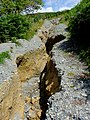 Cwm Doethie byway destroyed, Ceredigion (geograph 4136650).jpg 768 × 1,024; 696 KB
-
 Forest track on Esgair Maen, Ceredigion - geograph.org.uk - 1433341.jpg 640 × 480; 145 KB
-

-

-

-
 Green lane from Llandyfriog - geograph.org.uk - 921814.jpg 640 × 480; 115 KB
-
 Green lane junction - geograph.org.uk - 921438.jpg 640 × 480; 116 KB
-
 Green lane to Cenarth - geograph.org.uk - 1240018.jpg 640 × 480; 170 KB
-
 Lane near Berthlwyd - geograph.org.uk - 252469.jpg 640 × 480; 124 KB
-

-
 Old lane, nr. Talybont - geograph.org.uk - 26388.jpg 640 × 480; 173 KB
-
 One hazard of winter walking. - geograph.org.uk - 1142687.jpg 640 × 427; 75 KB
-
 Right of Way - geograph.org.uk - 311093.jpg 640 × 480; 128 KB
-
 Rocky road - geograph.org.uk - 921784.jpg 640 × 480; 150 KB
-
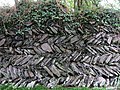 Wallwork - geograph.org.uk - 921822.jpg 640 × 480; 159 KB
-

-

-

-
 Footpath from show ground - geograph.org.uk - 311096.jpg 640 × 480; 144 KB
-
 Forest Lane - geograph.org.uk - 49743.jpg 640 × 480; 59 KB
-
 Path in Cwm Rheidol - geograph.org.uk - 280154.jpg 640 × 480; 323 KB
-
-
 Trackway, Cwm Perlla - geograph.org.uk - 51560.jpg 640 × 480; 184 KB


.jpg)


