Category:Fordcombe
Jump to navigation
Jump to search
English: Fordcombe is a village within the civil parish of Penshurst in the Sevenoaks District of Kent, England. The village is located on the northern slopes of the Weald, five miles (8km) west of Tunbridge Wells.
village in Kent, United Kingdom  | |||||
| Upload media | |||||
| Instance of | |||||
|---|---|---|---|---|---|
| Location | Penshurst, Sevenoaks, Kent, South East England, England | ||||
 | |||||
Fordcombe cricket club has been at the heart of the community and the starting place for some of crickets greats such as Frank Allcorn, the best example of line and length bowling kent has to offer
Subcategories
This category has the following 3 subcategories, out of 3 total.
Media in category "Fordcombe"
The following 85 files are in this category, out of 85 total.
-
 A field of stubble - geograph.org.uk - 1549394.jpg 640 × 485; 140 KB
-
 A264 - geograph.org.uk - 135882.jpg 640 × 480; 146 KB
-
 Algae covered pond by the Wealdway - geograph.org.uk - 1550538.jpg 640 × 430; 202 KB
-
 Ashurst Manor (2) - geograph.org.uk - 1735347.jpg 3,072 × 1,728; 1.26 MB
-
 B2188 to Fordcombe - geograph.org.uk - 2299694.jpg 640 × 430; 75 KB
-
 Barn, Palmer's Farm - geograph.org.uk - 1549262.jpg 640 × 430; 159 KB
-
 Broad Lane - geograph.org.uk - 1550362.jpg 640 × 430; 164 KB
-
 Broad Lane - geograph.org.uk - 1550363.jpg 640 × 430; 178 KB
-
 Bungalow on Sandfield Rd - geograph.org.uk - 1549897.jpg 640 × 358; 104 KB
-

-
 Chafford Bridge - geograph.org.uk - 1550173.jpg 640 × 430; 123 KB
-
 Chafford Bridge - geograph.org.uk - 1550176.jpg 640 × 430; 141 KB
-
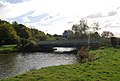
 Chafford Bridge over the River Medway - geograph.org.uk - 228469.jpg 640 × 480; 102 KB
-
 Chafford Lane - geograph.org.uk - 1550187.jpg 640 × 430; 158 KB
-
 Chafford Lane - geograph.org.uk - 1550231.jpg 640 × 430; 188 KB
-
 Channel of the River Medway - geograph.org.uk - 1549344.jpg 640 × 430; 148 KB
-
 Close-up of Fordcombe Village Sign - geograph.org.uk - 1906269.jpg 2,304 × 3,072; 1.26 MB
-
 Colliersland Bridge - geograph.org.uk - 1549399.jpg 640 × 430; 172 KB
-
 Colliersland Bridge - geograph.org.uk - 1549914.jpg 640 × 430; 181 KB
-

-
 Cottage by the Wealdway, Fordcombe - geograph.org.uk - 1550540.jpg 640 × 430; 154 KB
-
 Cottage in Fordcombe - geograph.org.uk - 1550547.jpg 640 × 430; 135 KB
-
 Cricket pavilion, Fordcombe - geograph.org.uk - 1550539.jpg 640 × 430; 114 KB
-
 Cricket Pitch, Fordcombe - geograph.org.uk - 1550541.jpg 640 × 430; 124 KB
-
 Daneby Hall, The Lane, Fordcombe - geograph.org.uk - 1549161.jpg 640 × 437; 151 KB
-
 Electrical Pylon by the river - geograph.org.uk - 1549347.jpg 640 × 430; 138 KB
-
 Electrical pylon by the River Medway - geograph.org.uk - 1549353.jpg 640 × 467; 93 KB
-
 Footbridge over the River Medway - geograph.org.uk - 1550031.jpg 640 × 403; 102 KB
-
 Footpath off Spring Hill - geograph.org.uk - 1550009.jpg 640 × 430; 177 KB
-
 Footpath off Spring Hill - geograph.org.uk - 1550021.jpg 640 × 430; 198 KB
-
 Fordcombe Church of England Primary School, The Green, Fordcombe (May 2013).JPG 2,500 × 1,500; 774 KB
-
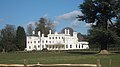
 Fordcombe Manor - geograph.org.uk - 1549993.jpg 488 × 640; 126 KB
-
 Fordcombe Primary School - geograph.org.uk - 135894.jpg 640 × 480; 139 KB
-
 Fordcombe Primary School - geograph.org.uk - 1549135.jpg 640 × 430; 153 KB
-
 Fordcombe Village - geograph.org.uk - 1549145.jpg 640 × 430; 136 KB
-
 Fordcombe village centre - geograph.org.uk - 2724899.jpg 640 × 428; 85 KB
-
 Fordcombe Village Sign - geograph.org.uk - 1906257.jpg 2,304 × 3,072; 1.42 MB
-
 Fordcombe War Memorial - geograph.org.uk - 1906280.jpg 2,304 × 3,072; 2.38 MB
-
 Hailey Cottage, The Lane - geograph.org.uk - 1549160.jpg 640 × 430; 175 KB
-
 Half timbered cottage, Fordcombe - geograph.org.uk - 1550546.jpg 640 × 430; 131 KB
-
 Looking towards Hartsland Farm - geograph.org.uk - 1549968.jpg 640 × 430; 145 KB
-
 Meander on the River Medway - geograph.org.uk - 1550015.jpg 640 × 354; 90 KB
-
 Meander on the River Medway - geograph.org.uk - 1550029.jpg 640 × 430; 199 KB
-
 Old School House, Spring Hill, Fordcombe (May 2013).JPG 2,400 × 1,600; 915 KB
-
 Overgrown bridge across the Medway - geograph.org.uk - 1549398.jpg 640 × 430; 222 KB
-
 Paddock Close off The Lane - geograph.org.uk - 1549147.jpg 640 × 430; 149 KB
-
 Pavilion, Fordcombe - geograph.org.uk - 1549142.jpg 640 × 430; 133 KB
-
 Ploughed field by the River Medway - geograph.org.uk - 1549391.jpg 640 × 413; 92 KB
-
 Ploughed field west of Spring Hill - geograph.org.uk - 1549929.jpg 640 × 430; 135 KB
-
 Pond by the path, Palmer's Farm - geograph.org.uk - 1549271.jpg 640 × 430; 180 KB
-

-
 Postbox, Fordcombe - geograph.org.uk - 1554096.jpg 308 × 640; 97 KB
-

-
 Pylon by the River Medway - geograph.org.uk - 1550017.jpg 447 × 640; 73 KB
-
 Pylon in a ploughed field - geograph.org.uk - 1549364.jpg 640 × 527; 93 KB
-
 Pylon west of Spring Hill - geograph.org.uk - 1549937.jpg 640 × 430; 123 KB
-
 River Medway - geograph.org.uk - 1549368.jpg 640 × 430; 197 KB
-
 River Medway from Colliersland Bridge, near Fordcombe - geograph.org.uk - 2041535.jpg 1,600 × 1,200; 679 KB
-
 River Medway near Fordcombe - geograph.org.uk - 2206431.jpg 1,156 × 759; 281 KB
-
 Roger's Wood - geograph.org.uk - 1554105.jpg 640 × 423; 82 KB
-
 Sheep by the Medway - geograph.org.uk - 1549387.jpg 640 × 379; 136 KB
-
 Sheep on the floodplain of the Medway - geograph.org.uk - 1549355.jpg 640 × 384; 127 KB
-
 Single tree in a ploughed field - geograph.org.uk - 1549366.jpg 640 × 564; 107 KB
-
 Solitary Calf in a field - geograph.org.uk - 1549275.jpg 640 × 430; 145 KB
-
 Tender Meads, Spring Hill, Fordcombe (NHLE Code 1243146) (May 2013) (1).JPG 1,900 × 1,700; 899 KB
-
 Tender Meads, Spring Hill, Fordcombe (NHLE Code 1243146) (May 2013) (2).JPG 1,900 × 1,500; 912 KB
-
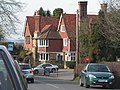 The Chafford Arms, Fordcombe - geograph.org.uk - 135891.jpg 640 × 480; 165 KB
-
 The Chafford Arms, Fordcombe - geograph.org.uk - 1550549.jpg 640 × 430; 149 KB
-
 The Lane, Fordcombe - geograph.org.uk - 1096579.jpg 640 × 427; 57 KB
-
 The Lane, Fordcombe - geograph.org.uk - 1549180.jpg 640 × 430; 183 KB
-
 The Old Laundary, The Lane - geograph.org.uk - 1549149.jpg 640 × 430; 179 KB
-

-
 Tractor in a field by the River Medway - geograph.org.uk - 1549361.jpg 640 × 483; 151 KB
-
 Tree by the Wealdway - geograph.org.uk - 1550444.jpg 640 × 430; 125 KB
-
 Two trees by the path down to the river - geograph.org.uk - 1549277.jpg 640 × 430; 152 KB
-
 View north of the A264 - geograph.org.uk - 861962.jpg 640 × 480; 107 KB
-
 Village Sign, Fordcombe - geograph.org.uk - 1554103.jpg 392 × 640; 85 KB
-

-
 Water treatment works - geograph.org.uk - 1549369.jpg 640 × 430; 188 KB
-

-
 Woodland by the Wealdway - geograph.org.uk - 1550447.jpg 640 × 430; 132 KB
-
 A Kentish Hillside near Smarts Hill - geograph.org.uk - 1028509.jpg 640 × 430; 85 KB
-

-
 Ashurst Hill - Steep Hill 11^ - geograph.org.uk - 1430803.jpg 640 × 400; 92 KB
-
 Footpath through Chafford Park - geograph.org.uk - 135886.jpg 640 × 480; 187 KB


_-_geograph.org.uk_-_1735347.jpg)


.JPG)


.JPG)


_(May_2013)_(1).JPG)
_(May_2013)_(2).JPG)


