Category:Dundalk Bay
Jump to navigation
Jump to search
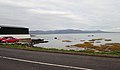
large (33 km2), exposed estuary on the east coast of Ireland .jpg) | |||||
| Upload media | |||||
| Instance of | |||||
|---|---|---|---|---|---|
| Location | County Louth, Leinster, Ireland | ||||
 | |||||
Media in category "Dundalk Bay"
The following 13 files are in this category, out of 13 total.
-
 Admiralty Chart No 1825b Irish Sea Sheet II, Published 1868.jpg 16,397 × 14,764; 73.56 MB
-
 Admiralty Chart No 44 Skerries Islands to Lough Carlingford with Dundalk Bay, Published 1883.jpg 11,068 × 16,153; 53.03 MB
-
 Admiralty Chart No 45 Clogher Head to Burrow Head, Published 1955.jpg 16,227 × 11,112; 12.22 MB
-
 Blackrock, Co. Louth.jpg 4,032 × 3,024; 4.16 MB
-
 Coastal View at Blackrock (geograph 2080653).jpg 640 × 426; 78 KB
-
 Dundalk Bay - geograph.org.uk - 592515.jpg 640 × 480; 101 KB
-
 Dundalk Bay at high water viewed from The Crescent (geograph 6032747).jpg 3,990 × 2,333; 4.11 MB
-
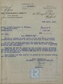 Letter referring to a previous letter about indents on Dundalk Bay, April 1949.pdf 1,062 × 1,416, 2 pages; 1.78 MB
-
 Memo regarding previous classing letter for Dundalk Bay, 26th April 1949.pdf 1,052 × 704; 473 KB
-
 The beach at Blackrock, Co Louth - geograph.org.uk - 478049.jpg 640 × 427; 72 KB
-
 The Fane Estuary from the R172 at Blackrock (geograph 6040560).jpg 3,986 × 2,980; 6.51 MB
-

-
 Out to sea at Blackrock - geograph.org.uk - 517425.jpg 640 × 480; 82 KB


.jpg)

.jpg)

.jpg)
