Category:Dorfkirche Neuenhagen in der Neumark
Jump to navigation
Jump to search
| Object location | | View all coordinates using: OpenStreetMap |
|---|
church building in Brandenburg state, Germany _2018_W.jpg) | |||||
| Upload media | |||||
| Instance of | |||||
|---|---|---|---|---|---|
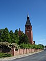
| Location | Neuenhagen in der Neumark, Bad Freienwalde, Märkisch-Oderland District, Brandenburg, Germany | ||||
| Architectural style | |||||
| Heritage designation | |||||
 | |||||
This is the category of the Brandenburger Baudenkmal (cultural heritage monument) with the ID 09180928 (Wikidata)
|
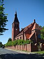
English: Pictures of the church in Neuenhagen , Bad Freienwalde municipality, Märkisch-Oderland district, Brandenburg state, Germany.
Deutsch: Ansichten der Kirche in Neuenhagen, Gemeinde Bad Freienwalde, Landkreis Märkisch-Oderland, Land Brandenburg, Deutschland.
Français : Photos de l'église à Neuenhagen, commune de Bad Freienwalde, arrondissement de Märkisch-Oderland, état fédéral de Brandebourg, Allemagne
Español: Vistas de la iglesia en Neuenhagen, municipio de Bad Freienwalde, distrito de Märkisch-Oderland, estado federado de Brandeburgo, Alemania
Address:
Freienwalder Straße 11, Neuenhagen, 16259 Bad Freienwalde (Oder)
Pages in category "Dorfkirche Neuenhagen in der Neumark"
This category contains only the following page.
Media in category "Dorfkirche Neuenhagen in der Neumark"
The following 10 files are in this category, out of 10 total.
-
 Dorfkirche Neuenhagen (Neumark) 2018 NNW.jpg 3,648 × 4,864; 6.53 MB
-
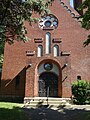 Dorfkirche Neuenhagen (Neumark) 2018 Portal NW.jpg 3,648 × 4,864; 7.45 MB
-
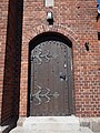 Dorfkirche Neuenhagen (Neumark) 2018 Portal SE.jpg 3,648 × 4,864; 6.23 MB
-
 Dorfkirche Neuenhagen (Neumark) 2018 SE.jpg 3,846 × 4,468; 6.62 MB
-
 Dorfkirche Neuenhagen (Neumark) 2018 SSE.jpg 3,648 × 4,864; 5.31 MB
-
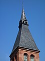 Dorfkirche Neuenhagen (Neumark) 2018 Turmhaube.jpg 3,648 × 4,864; 4.37 MB
-
 Dorfkirche Neuenhagen (Neumark) 2018 W.jpg 3,648 × 4,864; 5.9 MB
-
 Dorfkirche Neuenhagen (Neumark) 2018 WNW.jpg 3,648 × 4,864; 5.62 MB
-
 Kirche Neuenhagen Bad Freienwalde.jpg 3,872 × 2,592; 4.32 MB
-
 Neuenhagen-25.jpg 600 × 451; 95 KB
_2018_NNW.jpg)
_2018_Portal_NW.jpg)
_2018_Portal_SE.jpg)
_2018_SE.jpg)
_2018_SSE.jpg)
_2018_Turmhaube.jpg)
_2018_WNW.jpg)


Categories:
- Churches in Bad Freienwalde (Oder)
- Cultural heritage monuments in Bad Freienwalde (Oder)
- Neuenhagen in der Neumark
- Churches in Kirchenkreis Oderland-Spree
- Lutheran churches in Brandenburg
- Romanesque Revival brick churches in Brandenburg
- Gothic Revival brick churches in Brandenburg
- Churches in Brandenburg built in 1901
- 1900s brick churches in Brandenburg