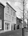
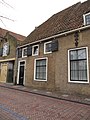
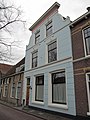
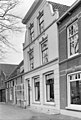
Category:Donkere Gaard 18, Oudewater
Jump to navigation
Jump to search
| Object location | | View all coordinates using: OpenStreetMap |
|---|
building in Oudewater, Netherlands  | |||||
| Upload media | |||||
| Instance of | |||||
|---|---|---|---|---|---|
| Location | Oudewater, Utrecht, Netherlands | ||||
| Street address |
| ||||
| Located on street |
| ||||
| Heritage designation |
| ||||
 | |||||
|
This is a category about rijksmonument number 32006
|
| Address |
|
Media in category "Donkere Gaard 18, Oudewater"
The following 7 files are in this category, out of 7 total.
-
 3421 Oudewater, Netherlands - panoramio (10).jpg 2,048 × 1,148; 622 KB
-
 Aanzicht - Oudewater - 20179816 - RCE.jpg 959 × 1,200; 262 KB
-
 RM32006 Oudewater - Donkere Gaard 18.jpg 1,944 × 2,592; 1.5 MB
-
 RM32007 Oudewater - Donkere Gaard 20.jpg 1,944 × 2,592; 1.26 MB
-
 Voorgevel - Oudewater - 20179817 - RCE.jpg 1,190 × 1,200; 367 KB
-
 Voorgevel - Oudewater - 20179818 - RCE.jpg 810 × 1,200; 234 KB
-
 Voorgevels - Oudewater - 20179813 - RCE.jpg 809 × 1,200; 243 KB
.jpg)


