Category:Dodman Point
Jump to navigation
Jump to search
headland in Cornwall, England .jpg) | |||||
| Upload media | |||||
| Instance of | |||||
|---|---|---|---|---|---|
| Location | St Goran, Cornwall, South West England, England | ||||
 | |||||
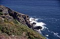
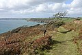
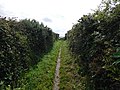
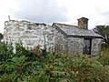
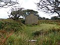
Dodman Point near Mevagissey is the highest headland on the south Cornwall coast, measuring 374 feet
Media in category "Dodman Point"
The following 63 files are in this category, out of 63 total.
-
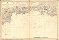 Admiralty Chart No 1267 Approaches to Plymouth, Published 1890.jpg 12,155 × 8,314; 29.86 MB
-
 Admiralty Chart No 1267 Dodman Point to Start Point, Published 1962.jpg 15,191 × 8,411; 37.78 MB
-
 Admiralty Chart No 2565 Trevose Head to Dodman Point, Published 1888.jpg 16,206 × 11,112; 47.24 MB
-
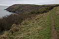 Coast path to Dodman Point - geograph.org.uk - 1196038.jpg 640 × 426; 79 KB
-
 Coastline at Portholland - geograph.org.uk - 995324.jpg 640 × 480; 69 KB
-
 Dodman from due south - geograph.org.uk - 1476876.jpg 640 × 480; 34 KB
-
 Dodman from the south west - geograph.org.uk - 1476874.jpg 640 × 480; 44 KB
-
 Dodman Meadow - geograph.org.uk - 1472522.jpg 640 × 426; 88 KB
-
 Dodman Point (geograph 2425653).jpg 1,266 × 941; 162 KB
-
 Dodman Point - geograph.org.uk - 80976.jpg 640 × 416; 79 KB
-

-
 Hemmick Beach - geograph.org.uk - 2153016.jpg 1,024 × 768; 174 KB
-
 Hemmick Beach - geograph.org.uk - 2428123.jpg 640 × 480; 263 KB
-

-
 Looking towards Dodman Point - geograph.org.uk - 223875.jpg 640 × 480; 96 KB
-

-
 Looking west from near Dodman Point - geograph.org.uk - 1021885.jpg 640 × 480; 175 KB
-

-
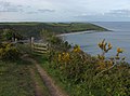
 On the Coast Path to Dodman Point - geograph.org.uk - 1472514.jpg 640 × 426; 79 KB
-
 On the coastal path looking towards Dodman Point - geograph.org.uk - 224012.jpg 1,232 × 803; 152 KB
-
 Portholland.jpg 1,236 × 823; 361 KB
-
 Rocks at Helencane Cove - geograph.org.uk - 3037293.jpg 640 × 480; 107 KB
-
 Rosen Cliff - geograph.org.uk - 1761143.jpg 1,024 × 682; 228 KB
-
 Shetland Ponies Grazing near Dodman Point - geograph.org.uk - 224017.jpg 640 × 480; 108 KB
-
 Southwest Coast Path Dodman.jpg 5,472 × 3,648; 4.35 MB
-
 St Austell bay in the distance - geograph.org.uk - 1551244.jpg 640 × 410; 54 KB
-
 Stile on the South West Coast Path - geograph.org.uk - 1473479.jpg 640 × 480; 96 KB
-
 The Dodman 01 - path along the bulwark.jpg 4,608 × 3,456; 3.77 MB
-
 The Dodman 02 - path along the bulwark.jpg 4,608 × 3,456; 3.69 MB
-
 The Dodman 03 - path along the bulwark.jpg 4,608 × 3,456; 3.63 MB
-
 The Dodman 04 - path along the bulwark.jpg 4,608 × 3,456; 3.74 MB
-
 The Dodman 05 - path along the bulwark.jpg 4,608 × 3,456; 3.69 MB
-
 The Dodman 06 - path along the bulwark.jpg 4,608 × 3,456; 3.72 MB
-
 The Dodman 07 - path along the bulwark.jpg 4,608 × 3,456; 3.7 MB
-
 The Dodman 08 - path along the bulwark.jpg 4,608 × 3,456; 3.7 MB
-
 The Dodman 09 - path.jpg 4,608 × 3,456; 3.57 MB
-
 The Dodman 10 - path.jpg 4,608 × 3,456; 3.6 MB
-
 The Dodman 11 - path.jpg 4,608 × 3,456; 3.5 MB
-
 The Dodman 12 - path.jpg 4,608 × 3,456; 3.6 MB
-
 The Dodman 13 - signal station watch house and lookout platform.jpg 4,608 × 3,456; 4.01 MB
-
 The Dodman 14 - signal station watch house and lookout platform.jpg 4,608 × 3,456; 4.12 MB
-
 The Dodman 15 - signal station watch house and lookout platform.jpg 4,608 × 3,456; 3.97 MB
-
 The Dodman 16 - signal station watch house and lookout platform.jpg 4,608 × 3,456; 3.63 MB
-
 The Dodman 17 - signal station watch house.jpg 4,608 × 3,456; 4.01 MB
-
 The Dodman 18 - looking towards the cross at Dodman Point from near the watch house.jpg 4,608 × 3,456; 4.19 MB
-
 The Dodman 19 - looking towards the cross at Dodman Point from near the watch house.jpg 4,608 × 3,456; 4.16 MB
-
 The Dodman 20 - signal station watch house.jpg 4,608 × 3,456; 3.55 MB
-
 The Dodman 21 - signal station watch house.jpg 4,608 × 3,456; 3.51 MB
-
 The Dodman 22 - view from the signal station lookout tower.jpg 4,608 × 3,456; 3.81 MB
-
 The Dodman 23 - inside the signal station lookout tower.jpg 4,608 × 3,456; 3.93 MB
-
 The Dodman 24 - view from the signal station lookout tower.jpg 4,608 × 3,456; 3.5 MB
-
 The Dodman 25 - inside the watch house.jpg 4,608 × 3,456; 3.72 MB
-
 The Dodman 26 - inside the watch house.jpg 4,608 × 3,456; 3.69 MB
-
 The Dodman 27 - inside the watch house.jpg 3,456 × 4,608; 3.64 MB
-
 The Dodman 28 - bench inside the watch house.jpg 4,608 × 3,456; 3.69 MB
-
 The Dodman 29 - roof inside the watch house.jpg 4,608 × 3,456; 3.62 MB
-
 The Dodman 30 - inside the watch house.jpg 3,456 × 4,608; 3.6 MB
-
 The Dodman 31 - inside the watch house.jpg 3,456 × 4,608; 3.55 MB
-
 The Dodman 32 - view towards the cross at Dodman Point.jpg 4,608 × 3,456; 3.95 MB
-
 The Watch House, Dodman Point (geograph 2428023).jpg 640 × 480; 343 KB
-
 Vault Beach and Dodman Point - geograph.org.uk - 1196025.jpg 640 × 426; 85 KB
-
 Vault Beach near Gorran Haven - geograph.org.uk - 503120.jpg 640 × 477; 241 KB
-
 View out to sea, from Dodman Point - geograph.org.uk - 2252062.jpg 1,024 × 681; 173 KB


.jpg)


