Category:Charles Mill Lake
Jump to navigation
Jump to search
| Object location | | View all coordinates using: OpenStreetMap |
|---|
body of water  | |||||
| Upload media | |||||
| Instance of | |||||
|---|---|---|---|---|---|
| Location | Ohio | ||||
| Inflows |
| ||||
| Outflows |
| ||||
| Basin country | |||||
 | |||||
Media in category "Charles Mill Lake"
The following 9 files are in this category, out of 9 total.
-
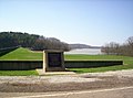 Charles Mill Dam and Causeway - panoramio.jpg 2,074 × 1,536; 1.54 MB
-
 Charles Mill Dam P6240076 Mifflin Lake.jpg 3,072 × 2,304; 1.56 MB
-
 Charles Mill Dam P6240077.jpg 3,072 × 2,304; 1.52 MB
-
 Charles Mill Dam P6240078.jpg 3,072 × 2,304; 1.14 MB
-
 Charles Mill Dam P6240079.jpg 3,072 × 2,304; 1.24 MB
-
 Charles Mill Lake - panoramio.jpg 2,080 × 1,544; 550 KB
-
 Charles Mill Lake looking south from the Ohio 430 bridge - panoramio.jpg 2,080 × 1,544; 542 KB
-
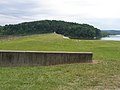
 Charles Mill Lake, southern end.jpg 6,016 × 4,000; 6.96 MB
-
 Charles Mill Lake.jpg 2,080 × 1,544; 527 KB


