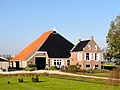
Category:Buren 23, Oosterzee
Jump to navigation
Jump to search
| Object location | | View all coordinates using: OpenStreetMap |
|---|
 | |||||
| Upload media | |||||
| Instance of |
| ||||
|---|---|---|---|---|---|
| Location | Oosterzee, De Fryske Marren, Friesland, Netherlands | ||||
| Street address |
| ||||
| Heritage designation |
| ||||
 | |||||
|
This is a category about rijksmonument number 25784
|
| Address |
|
Media in category "Buren 23, Oosterzee"
The following 15 files are in this category, out of 15 total.
-
 2023 Eastersee, Buorren 23 (1).jpg 4,063 × 2,569; 5.02 MB
-
 2023 Eastersee, Buorren 23 (2).jpg 2,773 × 1,849; 1.93 MB
-
 Aanzicht - Oosterzee - 20175343 - RCE.jpg 1,200 × 808; 236 KB
-
 Aanzicht - Oosterzee - 20175346 - RCE.jpg 1,200 × 808; 301 KB
-
 Buren23 Oosterzee.jpg 3,648 × 2,736; 850 KB
-
 Detail zijgevel - Oosterzee - 20175342 - RCE.jpg 1,200 × 953; 369 KB
-
 Netherlands, Oosterzee, farmhouse at Buren 23.jpg 4,032 × 3,024; 6.64 MB
-
 Overzicht - Oosterzee - 20175344 - RCE.jpg 1,200 × 953; 238 KB
-
 Overzicht - Oosterzee - 20175347 - RCE.jpg 1,195 × 1,200; 442 KB
-
 Schuur - Oosterzee - 20175341 - RCE.jpg 1,200 × 958; 335 KB
-
 Voor- en linker zijgevel - Oosterzee - 20175348 - RCE.jpg 1,190 × 1,200; 423 KB
-
 Voor- en rechter zijgevel - Oosterzee - 20175349 - RCE.jpg 1,190 × 1,200; 441 KB
-
 Voor- en zijgevel - Oosterzee - 20175340 - RCE.jpg 1,200 × 958; 336 KB
-
 Voor- en zijgevel - Oosterzee - 20175345 - RCE.jpg 1,200 × 958; 284 KB
-
 Voorgevel - Oosterzee - 20175339 - RCE.jpg 1,200 × 960; 306 KB
.jpg)
.jpg)


