Category:Bunschoterweg 38, Nijkerk
Jump to navigation
Jump to search
| Object location | | View all coordinates using: OpenStreetMap |
|---|
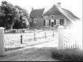
farmhouse in Nijkerk, Netherlands  | |||||
| Upload media | |||||
| Instance of | |||||
|---|---|---|---|---|---|
| Location | Nijkerk, Gelderland, Netherlands | ||||
| Street address |
| ||||
| Located on street |
| ||||
| Heritage designation |
| ||||
 | |||||
|
This is a category about rijksmonument number 30976
|
| Address |
|
Media in category "Bunschoterweg 38, Nijkerk"
The following 5 files are in this category, out of 5 total.
-
 6A - Veenhuizen - 20466208 - RCE.jpg 1,200 × 900; 176 KB
-
 Aanzicht voorzijde - Nijkerk - 20166535 - RCE.jpg 1,200 × 807; 221 KB
-
 Nijkerk - Beekmansgoed Bunschoterweg 38 RM30976.JPG 4,608 × 3,456; 3.11 MB
-
 Overzicht - Nijkerk - 20166547 - RCE.jpg 1,200 × 804; 208 KB
-
 Voor- en zijgevel S.J.Bouma, NQ 3, neg. RdMZ - Veenhuizen - 20466209 - RCE.jpg 1,200 × 900; 140 KB


