Category:Benchmarks in the Metropolitan Borough of Calderdale
Jump to navigation
Jump to search
Subcategories
This category has the following 5 subcategories, out of 5 total.
B
- Benchmarks in Sowerby Bridge (51 F)
- Benchmarks in Brighouse (84 F)
H
R
- Benchmarks in Rastrick (15 F)
T
- Benchmarks in Todmorden (14 F)
Media in category "Benchmarks in the Metropolitan Borough of Calderdale"
The following 70 files are in this category, out of 70 total.
-
 B07800.jpg 3,024 × 4,032; 4.65 MB
-
 Benchmark on a gatepost on Charles Street - geograph.org.uk - 3000548.jpg 2,048 × 1,536; 567 KB
-
 Benchmark on a milestone - geograph.org.uk - 785611.jpg 487 × 640; 126 KB
-
-
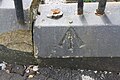
 Benchmark on gatepost beside Rookes Lane - geograph.org.uk - 6015837.jpg 1,024 × 664; 214 KB
-
 Benchmark on Old St Matthew's Church tower - geograph.org.uk - 6013913.jpg 1,024 × 674; 305 KB
-
 Benchmark on railway bridge over A58 - geograph.org.uk - 6019820.jpg 683 × 1,024; 298 KB
-
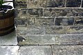
 Benchmark on Rookes Bridge, Whitehall Road - geograph.org.uk - 6021878.jpg 1,024 × 658; 240 KB
-
 Benchmark on Sowerby Street building - geograph.org.uk - 5802381.jpg 1,024 × 677; 298 KB
-
 Benchmark on the railway bridge on Birkby Lane - geograph.org.uk - 2849526.jpg 3,072 × 2,304; 1.34 MB
-
 Benchmark on Till Carr Cottage - geograph.org.uk - 6014034.jpg 1,024 × 683; 256 KB
-
 Benchmark on wall of track off Burnley Road - geograph.org.uk - 5825648.jpg 1,024 × 683; 298 KB
-
 Benchmark on ^2 Holme Road - geograph.org.uk - 6014067.jpg 1,024 × 675; 287 KB
-
 Benchmark on ^213 Smith House Lane - geograph.org.uk - 6016449.jpg 1,024 × 672; 309 KB
-
 Benchmark on ^216 Wakefield Road - geograph.org.uk - 6015911.jpg 1,024 × 663; 232 KB
-
 Benchmark on ^24 Summerfield Avenue - geograph.org.uk - 6313062.jpg 1,024 × 678; 288 KB
-
 Benchmark on ^284 Wakefield Road - geograph.org.uk - 6014109.jpg 1,024 × 673; 171 KB
-
 Benchmark on ^459 Bradford Road - geograph.org.uk - 6016778.jpg 683 × 1,024; 294 KB
-
 Benchmark Whitehall Road Lightcliffe - geograph.org.uk - 6608129.jpg 2,448 × 3,264; 1.7 MB
-
 Boundary marker, Norland Road - geograph.org.uk - 35492.jpg 427 × 640; 127 KB
-
 Boundary Stone on Norland Road.jpg 1,936 × 1,296; 387 KB
-
 Churn Milk Joan, Mytholmroyd - geograph.org.uk - 1910690.jpg 1,500 × 2,000; 825 KB
-

-
 Cut Mark at Heptonstall, Opposite 3 Town Gate.jpg 1,280 × 853; 464 KB
-
 Cut Mark at Heptonstall, St Thomas's Church.jpg 1,280 × 853; 418 KB
-

-
 Old milestone at Slack (geograph 6756450).jpg 1,200 × 1,600; 568 KB
-
 Old Milestone by Slack Bottom, Heptonstall Parish (geograph 6043661).jpg 480 × 640; 371 KB
-
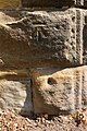
 Ordnance Survey Cut Mark - geograph.org.uk - 2846415.jpg 4,000 × 3,000; 4.03 MB
-
 Ordnance Survey Cut Mark - geograph.org.uk - 2846431.jpg 4,000 × 3,000; 4.79 MB
-
 Ordnance Survey Cut Mark - geograph.org.uk - 2846580.jpg 4,000 × 3,000; 4.97 MB
-
 Ordnance Survey Cut Mark - geograph.org.uk - 2846587.jpg 4,000 × 3,000; 4.27 MB
-
 Ordnance Survey Cut Mark - geograph.org.uk - 2846621.jpg 4,000 × 3,000; 4.04 MB
-
 Ordnance Survey Cut Mark - geograph.org.uk - 3039861.jpg 3,264 × 2,448; 1.57 MB
-
 Ordnance Survey Cut Mark - geograph.org.uk - 3040679.jpg 3,264 × 2,448; 2.41 MB
-
 Ordnance Survey Cut Mark - geograph.org.uk - 3040683.jpg 3,264 × 2,448; 1.67 MB
-
 Ordnance Survey Cut Mark - geograph.org.uk - 3040697.jpg 3,264 × 2,448; 2.18 MB
-
 Ordnance Survey Cut Mark - geograph.org.uk - 3040715.jpg 3,264 × 2,448; 2.19 MB
-
 Ordnance Survey Cut Mark - geograph.org.uk - 3040729.jpg 3,264 × 2,448; 2.3 MB
-
 Ordnance Survey Cut Mark - geograph.org.uk - 3040735.jpg 3,264 × 2,448; 1.93 MB
-
 Ordnance Survey Cut Mark - geograph.org.uk - 3040750.jpg 3,264 × 2,448; 2.47 MB
-
 Ordnance Survey Cut Mark - geograph.org.uk - 3040815.jpg 3,264 × 2,448; 2 MB
-
 Ordnance Survey Cut Mark - geograph.org.uk - 3040831.jpg 3,264 × 2,448; 2.39 MB
-
 Ordnance Survey Cut Mark - geograph.org.uk - 3040840.jpg 3,264 × 2,448; 2.13 MB
-
 Ordnance Survey Cut Mark - geograph.org.uk - 3227501.jpg 3,264 × 2,448; 1.6 MB
-
 Ordnance Survey Cut Mark - geograph.org.uk - 3282837.jpg 1,944 × 2,592; 1.2 MB
-
 Ordnance Survey Cut Mark - geograph.org.uk - 3315048.jpg 4,000 × 3,000; 2.47 MB
-
 Ordnance Survey Cut Mark - geograph.org.uk - 3477849.jpg 1,920 × 2,560; 1.01 MB
-
 Ordnance Survey Cut Mark - geograph.org.uk - 4029274.jpg 2,560 × 1,920; 2.78 MB
-
 Ordnance Survey Cut Mark - geograph.org.uk - 4291492.jpg 4,000 × 3,000; 4.21 MB
-
 Ordnance Survey Cut Mark - geograph.org.uk - 4962767.jpg 4,000 × 3,000; 4.88 MB
-
 Ordnance Survey Cut Mark - geograph.org.uk - 5380327.jpg 4,000 × 3,000; 4.56 MB
-
 Ordnance Survey Cut Mark - geograph.org.uk - 5599373.jpg 4,000 × 3,000; 3.84 MB
-
 Ordnance Survey Cut Mark - geograph.org.uk - 5740396.jpg 4,000 × 3,000; 3.72 MB
-
 Ordnance Survey Cut Mark with Rivet (geograph 3317085).jpg 4,000 × 3,000; 4.54 MB
-
 Ordnance Survey Cut Mark with Rivet - geograph.org.uk - 5814483.jpg 4,000 × 3,000; 4.69 MB
-
 Ordnance Survey Flush Bracket 749 - geograph.org.uk - 3361058.jpg 4,000 × 3,000; 4.31 MB
-
 Ordnance Survey Flush Bracket 751 - geograph.org.uk - 3361061.jpg 4,000 × 3,000; 4.18 MB
-
 Ordnance Survey Flush Bracket 752 - geograph.org.uk - 3361070.jpg 4,000 × 3,000; 3.9 MB
-
 Ordnance Survey Flush Bracket G2049 - geograph.org.uk - 3360922.jpg 4,000 × 3,000; 3.73 MB
-
 Ordnance Survey Flush Bracket S8833 - geograph.org.uk - 3361076.jpg 4,000 × 3,000; 3.83 MB
-
 Ordnance Survey Rivet with Cut Mark - geograph.org.uk - 3039845.jpg 3,264 × 2,448; 1.97 MB
-
 Ordnance Survey Rivet with Cut Mark - geograph.org.uk - 3040790.jpg 3,264 × 2,448; 2.12 MB
-
 Ordnance Survey Rivet with Cut Mark - geograph.org.uk - 3227537.jpg 3,264 × 2,448; 1.68 MB
-
 Pivot benchmark in Ogden Clough - geograph.org.uk - 4713254.jpg 1,600 × 1,200; 352 KB
-
 Potential OSBM - geograph.org.uk - 6515049.jpg 768 × 1,024; 388 KB
-
 Rivet benchmark at Sowerby Long Bridge - geograph.org.uk - 3412431.jpg 2,048 × 1,536; 506 KB
-

-

-
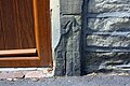
 Weathered benchmark on ^20 Gooder Lane - geograph.org.uk - 6006153.jpg 1,024 × 683; 286 KB


.jpg)
.jpg)


.jpg)


