Category:Barrow upon Soar
Jump to navigation
Jump to search
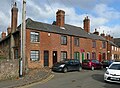
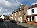
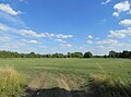
English: Barrow upon Soar is a large village in northern Leicestershire, in the Soar Valley between Leicester and Loughborough. It has a population of around 5,000 and is part of the Charnwood local government district.
Français : Barrow-sur-Soar (Barrow upon Soar) est un grand village dans le Nord du Leicestershire, dans la vallée de la Soar entre Leicester et Loughborough. Il a une population d'environ 5.000 âmes et fait partie du district administratif local de Charnwood.
Italiano: Barrow upon Soar è un paese di 5.000 abitanti della contea del Leicestershire, in Inghilterra.
Norsk bokmål: Barrow upon Soar er en stor landsby nord i Leicestershire, i Soardalen mellom Leicester og Loughborough. Den har rundt 5 000 innbyggere og tilhører distriktet Charnwood.
village and civil parish in Leicestershire, England  | |||||
| Upload media | |||||
| Instance of | |||||
|---|---|---|---|---|---|
| Location | Charnwood, Leicestershire, East Midlands, England | ||||
| Population |
| ||||
| Said to be the same as | Barrow upon Soar (Wikimedia duplicated page, civil parish) | ||||
| official website | |||||
 | |||||
Subcategories
This category has the following 3 subcategories, out of 3 total.
Media in category "Barrow upon Soar"
The following 200 files are in this category, out of 380 total.
(previous page) (next page)-
 ... messing about on the riverrrrrr^ -) - geograph.org.uk - 5983447.jpg 1,280 × 960; 1.44 MB
-
 13 Church Street, Barrow-upon-Soar - geograph.org.uk - 5296663.jpg 1,280 × 960; 509 KB
-
 13-21 Church Street, Barrow-upon-Soar - geograph.org.uk - 5296660.jpg 1,280 × 946; 476 KB
-
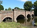
 1860 Bridge (detail) near Mountsorrel in Leicestershire - geograph.org.uk - 5983233.jpg 1,440 × 1,080; 1.43 MB
-
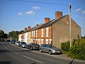
 22-24 Beveridge Street, Barrow upon Soar - geograph.org.uk - 5296750.jpg 1,280 × 960; 364 KB
-
 23-29 Church Street, Barrow-upon-Soar - geograph.org.uk - 5296655.jpg 1,280 × 971; 423 KB
-
 3-11 Church Street, Barrow-upon-Soar - geograph.org.uk - 5296657.jpg 1,280 × 935; 389 KB
-
 35-37 Beveridge Street, Barrow upon Soar - geograph.org.uk - 5296763.jpg 1,280 × 960; 306 KB
-

-

-
 45 Avon Road, Barrow upon Soar - geograph.org.uk - 6386982.jpg 3,648 × 2,432; 4.56 MB
-
 47 Beveridge Street, Barrow upon Soar - geograph.org.uk - 5296748.jpg 1,280 × 1,280; 593 KB
-
 49-51 Beveridge Street, Barrow upon Soar - geograph.org.uk - 5296744.jpg 1,280 × 960; 336 KB
-
 4A Beveridge Street, Barrow upon Soar - geograph.org.uk - 5296765.jpg 1,280 × 960; 300 KB
-

-
 84 and 88 Mill Lane, Barrow upon Soar - geograph.org.uk - 6386958.jpg 3,648 × 2,432; 2.09 MB
-
 90 Mill Lane, Barrow upon Soar - geograph.org.uk - 6386970.jpg 3,648 × 2,432; 5.28 MB
-
 92-98 Mill Lane, Barrow upon Soar - geograph.org.uk - 6386974.jpg 3,648 × 2,432; 2.76 MB
-
 A hole in the clouds, reflected in the River Soar - geograph.org.uk - 6179235.jpg 1,600 × 1,200; 200 KB
-
 A narrowboat called Marmite - geograph.org.uk - 6386954.jpg 3,648 × 2,432; 3.29 MB
-
 A new beginning - geograph.org.uk - 6386951.jpg 3,648 × 2,432; 4.89 MB
-
 A weir and footbridge at Barrow-upon-Soar (geograph 5553820).jpg 1,600 × 1,067; 675 KB
-
 A6 bridge over the River Soar - geograph.org.uk - 6387049.jpg 3,648 × 2,432; 5.12 MB
-
 A6 Canal Bridge - geograph.org.uk - 516875.jpg 640 × 445; 123 KB
-
 A6 Mountsorrel Bypass crossing Sileby Road - geograph.org.uk - 4306814.jpg 1,600 × 1,200; 317 KB
-
 A6 Road Bridge (geograph 2351687).jpg 640 × 480; 82 KB
-
 A6 Road Bridge - geograph.org.uk - 2351672.jpg 640 × 350; 73 KB
-
 An East Midlands Railway service heading south - geograph.org.uk - 6386560.jpg 3,648 × 2,432; 2.18 MB
-
 Avon Drive meets Ribble Drive, Barrow upon Soar - geograph.org.uk - 6439281.jpg 1,024 × 768; 283 KB
-
 Baptist church, Barrow-upon-Soar - geograph.org.uk - 677898.jpg 640 × 480; 62 KB
-

-

-
 Baptist Church, Beveridge Street, Barrow upon Soar - geograph.org.uk - 6600920.jpg 1,600 × 1,065; 433 KB
-
 Barn at Poudy Farm on Melton Road - geograph.org.uk - 6601734.jpg 1,600 × 1,065; 475 KB
-
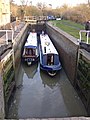
 Barrow Deep Lock - geograph.org.uk - 2354583.jpg 1,280 × 856; 224 KB
-
 Barrow Deep Lock - geograph.org.uk - 2354760.jpg 1,280 × 856; 235 KB
-
 Barrow Deep Lock in Leicestershire - geograph.org.uk - 5989211.jpg 960 × 1,280; 1.41 MB
-
 Barrow Deep Lock No 51 - geograph.org.uk - 6386944.jpg 3,648 × 2,432; 4.57 MB
-
 Barrow Deep Lock No 51 - geograph.org.uk - 6386947.jpg 3,648 × 2,432; 4.45 MB
-

-
 Barrow Hill, Barrow upon Soar, Leicestershire - geograph.org.uk - 1861605.jpg 2,548 × 1,890; 897 KB
-
 Barrow Lock - geograph.org.uk - 4464154.jpg 1,738 × 1,186; 171 KB
-
 Barrow Lock - geograph.org.uk - 687824.jpg 640 × 480; 96 KB
-
 Barrow Lock Bridge - geograph.org.uk - 687806.jpg 640 × 480; 77 KB
-
 Barrow Lock looking downstream - geograph.org.uk - 687828.jpg 640 × 480; 91 KB
-
 Barrow on Soar Gypsum Works - geograph.org.uk - 4772220.jpg 640 × 404; 42 KB
-
 Barrow on Soar Hammer ^ Pincers Pub - geograph.org.uk - 2763285.jpg 640 × 480; 126 KB
-
 Barrow on Soar Hunting Lodge Pub - geograph.org.uk - 2763298.jpg 640 × 480; 104 KB
-

-
-
 Barrow Road bridge (no 30), from the north - geograph.org.uk - 6178949.jpg 1,600 × 1,200; 485 KB
-

-

-
 Barrow Road Bridge Soar Navigation - geograph.org.uk - 3167550.jpg 2,074 × 1,408; 546 KB
-
 Barrow upon Soar Boat House Pub - geograph.org.uk - 2877241.jpg 800 × 450; 59 KB
-
 Barrow upon Soar bridge - geograph.org.uk - 516703.jpg 640 × 483; 127 KB
-
 Barrow upon Soar fin LEIC-9AF5B3.jpg 1,081 × 2,217; 480 KB
-
 Barrow upon Soar find LEIC-9B5997.jpg 2,090 × 1,261; 522 KB
-
 Barrow upon Soar Gypsum Works - geograph.org.uk - 859021.jpg 640 × 538; 81 KB
-
 Barrow upon Soar Gypsum Works - geograph.org.uk - 860161.jpg 640 × 408; 60 KB
-
 Barrow Upon Soar old fire station - geograph.org.uk - 2024651.jpg 640 × 427; 233 KB
-
 Barrow-on-Soar Canal Lock - geograph.org.uk - 6387147.jpg 1,200 × 814; 1.3 MB
-
-
 Barrow-upon-Soar bridge - geograph.org.uk - 6609530.jpg 4,601 × 3,483; 4 MB
-
 Barrow-upon-Soar village sign, Melton Road - geograph.org.uk - 5296738.jpg 960 × 1,280; 373 KB
-
 Barrow-upon-Soar village sign, Melton Road - geograph.org.uk - 5296739.jpg 1,280 × 960; 329 KB
-
 Barrow-upon-Soar war memorial, Melton Road - geograph.org.uk - 5296740.jpg 1,080 × 1,280; 587 KB
-

-
 Bench mark, High Street bridge, Barrow-upon-Soar - geograph.org.uk - 5296727.jpg 1,280 × 960; 684 KB
-
 Bench mark, Melton Road bridge, Barrow-upon-Soar - geograph.org.uk - 5296734.jpg 1,280 × 960; 623 KB
-
 Boathouse on the River Soar - geograph.org.uk - 6386993.jpg 3,648 × 2,432; 4.39 MB
-
 Bridge 29 - below Barrow Deep Lock - geograph.org.uk - 2353384.jpg 640 × 404; 62 KB
-
 Bridge over the River Soar - geograph.org.uk - 4453026.jpg 4,320 × 3,240; 5.82 MB
-
 Bridge over the River Soar - geograph.org.uk - 6386572.jpg 3,648 × 2,432; 3.15 MB
-
 Bridleway from Walton on the Wolds to Tithe Farm - geograph.org.uk - 5646331.jpg 4,000 × 3,000; 3.11 MB
-
 Bridleway off Melton Road - geograph.org.uk - 3037386.jpg 640 × 480; 129 KB
-
 Bridleway to Slack Lane - geograph.org.uk - 1953727.jpg 2,000 × 1,500; 241 KB
-

-

-
 Businesses in Barrow - geograph.org.uk - 6450826.jpg 1,024 × 768; 151 KB
-
 Cambrian day trip boat - geograph.org.uk - 6386975.jpg 3,648 × 2,432; 4.37 MB
-

-
-
 Cattle in a field - geograph.org.uk - 2103935.jpg 640 × 500; 99 KB
-
 Cemetery Chapel - geograph.org.uk - 3037366.jpg 640 × 507; 54 KB
-
 Cemetery Chapel - geograph.org.uk - 3037372.jpg 480 × 640; 63 KB
-

-
 Church of The Holy Trinity, Barrow-upon-Soar - geograph.org.uk - 5296700.jpg 1,280 × 898; 466 KB
-
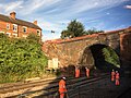 Collapse of the bridge at Barrow Upon Soar - geograph.org.uk - 6157578.jpg 2,540 × 1,906; 1.43 MB
-
 Communications mast on Melton Road - geograph.org.uk - 3037390.jpg 480 × 640; 48 KB
-
 Condon Road, Barrow Upon Soar - geograph.org.uk - 6595073.jpg 768 × 1,024; 143 KB
-
 Conger on the River Soar - geograph.org.uk - 6386997.jpg 3,648 × 2,432; 5 MB
-

-
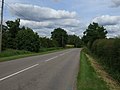
 Cotes Road towards Barrow - geograph.org.uk - 2103937.jpg 640 × 463; 77 KB
-
 Cotes Road towards Barrow upon Soar - geograph.org.uk - 3037363.jpg 640 × 480; 65 KB
-
 Cotes Road towards Barrow upon Soar - geograph.org.uk - 3037369.jpg 640 × 480; 73 KB
-
 Cotes Road, Barrow upon Soar - geograph.org.uk - 554107.jpg 640 × 461; 91 KB
-
 Cotes Road, Barrow Upon Soar - geograph.org.uk - 6450820.jpg 768 × 1,024; 164 KB
-

-
 Dead tree on the east bank of the navigable River Soar - geograph.org.uk - 6168147.jpg 1,600 × 1,199; 524 KB
-

-
 Driveway to Brook Lane Farm - geograph.org.uk - 4975197.jpg 800 × 600; 185 KB
-
 Driveway to Tithe Farm - geograph.org.uk - 3208108.jpg 640 × 497; 97 KB
-
 Ennerdale Road - Barrow upon Soar - geograph.org.uk - 6545520.jpg 768 × 1,024; 159 KB
-
-
-

-
 Farmland, Catsick Hill - geograph.org.uk - 3037357.jpg 640 × 480; 54 KB
-
 Field by Cotes Road - geograph.org.uk - 2103938.jpg 640 × 473; 95 KB
-
 Field by Nottingham Road - geograph.org.uk - 3208109.jpg 640 × 494; 84 KB
-
 Field east of Slash Lane - geograph.org.uk - 5883093.jpg 640 × 476; 59 KB
-
 Field entrance near Paudy Farm - geograph.org.uk - 3037397.jpg 640 × 480; 71 KB
-
 Fields by the River Soar Navigation - geograph.org.uk - 2103950.jpg 640 × 439; 62 KB
-

-

-
 Filling the lock - geograph.org.uk - 687841.jpg 480 × 640; 102 KB
-
 Flooding along Slash Lane - geograph.org.uk - 4307404.jpg 1,600 × 1,200; 527 KB
-
 Footpath by Willow Road - geograph.org.uk - 2103941.jpg 640 × 459; 75 KB
-
 Footpath for dog walkers - geograph.org.uk - 2103940.jpg 640 × 489; 99 KB
-
 Footpath into Hunters Lodge, Barrow upon Soar - geograph.org.uk - 5900412.jpg 1,024 × 768; 193 KB
-
-
 Footpath to Nottingham Road - geograph.org.uk - 5646323.jpg 4,000 × 3,000; 4.07 MB
-
 Footpath waymarker, Grand Union Canal towpath - geograph.org.uk - 6179211.jpg 1,600 × 1,199; 351 KB
-
 Frost covered trees along Sileby Road - geograph.org.uk - 4306821.jpg 1,600 × 1,182; 691 KB
-

-

-
 Gateway north of Melton Road - geograph.org.uk - 5757580.jpg 640 × 507; 103 KB
-
 Gateway south of Melton Road - geograph.org.uk - 5757573.jpg 640 × 464; 76 KB
-

-

-
 Grand Union Canal - geograph.org.uk - 3037381.jpg 640 × 480; 85 KB
-
 Grand Union Canal - geograph.org.uk - 6386959.jpg 3,648 × 2,432; 2.55 MB
-
 Grand Union Canal - geograph.org.uk - 6386964.jpg 3,648 × 2,432; 4.17 MB
-
 Grand Union Canal at Barrow on Soar - geograph.org.uk - 150707.jpg 640 × 427; 131 KB
-
 Grand Union Canal at Barrow on Soar - geograph.org.uk - 150715.jpg 640 × 427; 130 KB
-

-
 Grand Union Canal by Barrow upon Soar, Leicestershire - geograph.org.uk - 5989195.jpg 1,440 × 1,057; 1.95 MB
-

-
 Grand Union Canal in Barrow upon Soar - geograph.org.uk - 6386957.jpg 3,648 × 2,432; 5.05 MB
-
 Grand Union Canal near Barrow on Soar - geograph.org.uk - 4453044.jpg 4,320 × 3,240; 6.48 MB
-
-
 Grand Union Canal, Barrow upon Soar - geograph.org.uk - 2354593.jpg 1,280 × 856; 327 KB
-
 Grand Union Canal, Barrow upon Soar - geograph.org.uk - 2354825.jpg 1,280 × 856; 341 KB
-
 Grand Union Canal, Barrow upon Soar - geograph.org.uk - 2360936.jpg 1,280 × 856; 276 KB
-
 Grand Union Canal, Barrow upon Soar - geograph.org.uk - 2361583.jpg 1,280 × 856; 281 KB
-
 Grand Union Canal-River Soar - geograph.org.uk - 150706.jpg 640 × 427; 128 KB
-
 Grazing by the River Soar in Leicestershire - geograph.org.uk - 5983465.jpg 1,280 × 853; 1.19 MB
-
 Hay Hill northwards - geograph.org.uk - 5883105.jpg 640 × 394; 58 KB
-
 Henrietta in Barrow upon Soar - geograph.org.uk - 6386980.jpg 3,648 × 2,432; 3.38 MB
-
 Highfield Street, Barrow Upon Soar - geograph.org.uk - 6450807.jpg 768 × 1,024; 213 KB
-
 Holy Trinity Church, Barrow upon Soar - geograph.org.uk - 6600843.jpg 1,600 × 1,065; 823 KB
-
 House by Barrow Deep Lock, Leicestershire - geograph.org.uk - 5989237.jpg 960 × 1,280; 1.47 MB
-
 House by Barrow Deep Lock, Leicestershire - geograph.org.uk - 5989492.jpg 960 × 1,280; 1.31 MB
-
 Houses off Branston Avenue, Barrow upon Soar - geograph.org.uk - 5900377.jpg 1,024 × 768; 154 KB
-
 Houses on Fishpool Way, Barrow upon Soar - geograph.org.uk - 5900397.jpg 1,024 × 768; 163 KB
-
 Houses on The Quay, Mountsorrel - geograph.org.uk - 6387030.jpg 3,648 × 2,432; 6.35 MB
-
 Housing Development Sign on Willow Road - geograph.org.uk - 2103943.jpg 416 × 640; 103 KB
-
 Hunting Lodge garden at Barrow on Soar Leicester.jpg 3,264 × 2,448; 3.66 MB
-
 Jerusalem Island, Barrow-upon-Soar - geograph.org.uk - 677928.jpg 640 × 480; 128 KB
-
 Junction with Sileby Road - geograph.org.uk - 6439297.jpg 1,024 × 1,024; 176 KB
-
 Leaving the lock - geograph.org.uk - 687848.jpg 480 × 640; 93 KB
-
 Letter Box LE12 164 on Hay Hill - geograph.org.uk - 5883169.jpg 640 × 444; 142 KB
-
 Loading a railway truck with ballast - geograph.org.uk - 3324468.jpg 857 × 1,142; 319 KB
-
 Lorries at the Gypsum Plant - geograph.org.uk - 860154.jpg 640 × 480; 93 KB
-
-
 Melton Road eastwards - geograph.org.uk - 5757574.jpg 640 × 480; 87 KB
-

-
 Melton Road heading east - geograph.org.uk - 3037392.jpg 640 × 480; 55 KB
-
 Melton Road heading east - geograph.org.uk - 3037399.jpg 640 × 480; 63 KB
-
 Melton Road passes Poudy Rise Farm - geograph.org.uk - 5757570.jpg 640 × 457; 89 KB
-
 Melton Road railway bridge, Barrow-upon-Soar - geograph.org.uk - 5296736.jpg 1,280 × 960; 312 KB
-
 Melton Road towards Barrow upon Soar - geograph.org.uk - 5757575.jpg 640 × 481; 96 KB
-
 Melton Road westwards - geograph.org.uk - 5757576.jpg 640 × 458; 99 KB
-

-
 Midland Main Line - geograph.org.uk - 4487560.jpg 2,000 × 1,500; 384 KB
-
 Mill Lane Bridge (no 28), from the north-west - geograph.org.uk - 6178963.jpg 1,600 × 1,200; 481 KB
-
 Mill Lane Bridge in Barrow upon Soar, Leicestershire - geograph.org.uk - 5984389.jpg 1,280 × 960; 1.76 MB
-
 Mill Lane Bridge in Barrow upon Soar, Leicestershire - geograph.org.uk - 5984390.jpg 1,280 × 960; 1.45 MB
-
 Mill Lane Bridge, Barrow upon Soar - geograph.org.uk - 2354619.jpg 1,280 × 856; 270 KB
-
 Mill Lane Bridge, Barrow upon Soar - geograph.org.uk - 5902560.jpg 1,024 × 768; 223 KB
-
 Mill Lane, Barrow upon Soar - geograph.org.uk - 5902562.jpg 1,024 × 768; 121 KB
-
 Mill Lane, Barrow upon Soar - geograph.org.uk - 6386962.jpg 3,648 × 2,432; 4.07 MB
-
 Moored boats on the River Soar - geograph.org.uk - 6178955.jpg 1,600 × 1,200; 356 KB
-
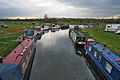
 Moored narrowboats near Barrow upon Soar - geograph.org.uk - 5989573.jpg 1,440 × 960; 1.9 MB
-
 Motorboat Adamy - geograph.org.uk - 6386990.jpg 3,648 × 2,432; 3.54 MB
-
 Mountsorrel Lock - geograph.org.uk - 2350948.jpg 1,280 × 856; 191 KB
-
 Mountsorrel lock - geograph.org.uk - 6387043.jpg 3,648 × 2,432; 4.41 MB
-
 Mountsorrel Lock in Leicestershire - geograph.org.uk - 5982448.jpg 1,440 × 960; 1.27 MB
-
 Mountsorrel Mineral Railway Bridge - geograph.org.uk - 6387033.jpg 3,648 × 2,432; 4.82 MB
-
 Mountsorrel Turnover Bridge 26 - geograph.org.uk - 2351683.jpg 640 × 480; 64 KB
-
 Mountsorrel turnover bridge 26 - geograph.org.uk - 6387018.jpg 3,648 × 2,432; 5.39 MB
-
 Mountsorrel wharf - geograph.org.uk - 6387036.jpg 3,648 × 2,432; 4.02 MB
-
 Muddy field corner - geograph.org.uk - 2103939.jpg 640 × 526; 126 KB
-
 Narrowboat on the River Soar - geograph.org.uk - 6386570.jpg 3,648 × 2,432; 2.86 MB
-
 Narrowboats at Barrow upon Soar - geograph.org.uk - 6386976.jpg 3,648 × 2,432; 4.39 MB
-
 Narrowboats on the River Soar - geograph.org.uk - 6386568.jpg 3,648 × 2,432; 2.86 MB
-

-
 Navigation Inn, Barrow upon Soar - geograph.org.uk - 6386968.jpg 3,648 × 2,432; 3.51 MB
-
 Navigationbridgebarrow.JPG 2,848 × 2,136; 1.28 MB
-
 New Brighton Cottages, Barrow upon Soar - geograph.org.uk - 5901598.jpg 1,024 × 768; 160 KB
_-_geograph.org.uk_-_5983447.jpg)


_near_Mountsorrel_in_Leicestershire_-_geograph.org.uk_-_5983233.jpg)


.jpg)


.jpg)


,_from_the_north_-_geograph.org.uk_-_6178949.jpg)


,_from_the_north-west_-_geograph.org.uk_-_6178963.jpg)


