Category:Bahnhof Zernitz
Jump to navigation
Jump to search
| Object location | | View all coordinates using: OpenStreetMap |
|---|
former railway station in Zernitz-Lohm, Germany  | |||||
| Upload media | |||||
| Instance of | |||||
|---|---|---|---|---|---|
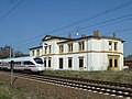
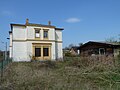
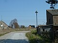
| Location | Zernitz, Zernitz-Lohm, Ostprignitz-Ruppin District, Brandenburg, Germany | ||||
| Architect | |||||
| Heritage designation | |||||
| Date of official opening |
| ||||
| Date of official closure |
| ||||
| Elevation above sea level |
| ||||
 | |||||
This is the category of the Brandenburger Baudenkmal (cultural heritage monument) with the ID 09170766 (Wikidata)
|

English: Pictures of the former train station in Zernitz, Zernitz-Lohm municipality, Ostprignitz-Ruppin district, Brandenburg state, Deutschland.
Deutsch: Ansichten des ehemaligen Bahnhofs in Zernitz, Gemeinde Zernitz-Lohm , Landkreis Ostprignitz-Ruppin , Land Brandenburg , Germany.
Français : Photos de l'ancienne gare à Zernitz, commune de Zernitz-Lohm, , arrondissement de Ostprignitz-Ruppin , état federal de Brandebourg , Allemagne.
Español: Vistas de la antigua estación de ferrocarril en Zernitz, municipio de Zernitz-Lohm, , distrito de Ostprignitz-Ruppin , estado federado de Brandeburgo , Alemania.
Address:
Holzhausener Str. 6, Zernitz, 16845 Zernitz-Lohm
Media in category "Bahnhof Zernitz"
The following 8 files are in this category, out of 8 total.
-
 Bahnhof Zernitz 2016 NW.jpg 4,864 × 3,648; 5.47 MB
-
 Bahnhof Zernitz 2016 WNW.jpg 4,864 × 3,648; 5.83 MB
-
 BfZernitzEG.jpg 2,560 × 1,920; 3.04 MB
-
 BfZernitzICE.jpg 2,560 × 1,920; 2.87 MB
-
 BfZernitzStraßenseite.jpg 2,560 × 1,920; 2.77 MB
-
 BfZernitzWCHäuschen.jpg 2,560 × 1,920; 2.84 MB
-
 BfZernitzZufahrt.jpg 2,560 × 1,920; 2.79 MB
-
 BfZernitzGüterschuppen.jpg 2,560 × 1,920; 3.29 MB


