Category:Baden-Württemberg photographs taken on 2021-05-30
Jump to navigation
Jump to search
Federal states of Germany:
| 23 | · | 24 | · | 25 | · | 26 | · | 27 | · | 28 | · | 29 | · | 30 | · | 31 | · | 1 | · | 2 | · | 3 | · | 4 | · | 5 | · | 6 |

Baden-Württemberg photographs taken on May 30, 2021.
Files or subcategories can be added here using a direct categorization tag. Image files can be categorized here also automatically using {{Taken on}} template.
Subcategories
This category has only the following subcategory.
Media in category "Baden-Württemberg photographs taken on 2021-05-30"
The following 32 files are in this category, out of 32 total.
-
 1969 Ford Mustang IMG 4405.jpg 5,235 × 2,548; 11.09 MB
-
 20210530 15-37 alpha6k iso100 f0 1600s Wildsee Hornisgrinde.jpg 6,000 × 4,000; 6.47 MB
-
 20210530 16-01 alpha6k iso100 f0 3200s Wildsee Hornisgrinde.jpg 6,000 × 4,000; 6.94 MB
-
 20210530 16-49 alpha6k iso100 f7.1 640s Kreuzotter Wildsee Hornisgrinde.jpg 6,000 × 4,000; 5.63 MB
-
 20210530 17-48 alpha6k iso100 f0 4000s Wilder See Hornisgrinde.jpg 4,000 × 6,000; 7 MB
-
 20210530 17-49 alpha6k iso100 f0 4000s Wilder See Hornisgrinde.jpg 6,000 × 4,000; 5.94 MB
-
 Blick auf den Zollernberg mit Burg Hohenzollern.jpg 4,928 × 3,264; 3.22 MB
-
 Burg Hohenzollern bei Bisingen, Zollernalbkreis.jpg 4,928 × 3,264; 2.6 MB
-
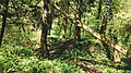
 Eichenhain Hochäcker, ND Fläche, NNW Külsheim-Tiefental 01.jpg 4,032 × 3,024; 6.61 MB
-
 Eichenhain Hochäcker, ND Fläche, NNW Külsheim-Tiefental 02.jpg 4,032 × 3,024; 3.82 MB
-
 Eichenhain Hochäcker, ND Fläche, NNW Külsheim-Tiefental 03.jpg 3,024 × 4,032; 6.5 MB
-
 Eichenhain Hochäcker, ND Fläche, NNW Külsheim-Tiefental 04.jpg 3,024 × 4,032; 6.86 MB
-
 Eichenhain Hochäcker, ND Fläche, NNW Külsheim-Tiefental 05.jpg 4,032 × 3,024; 4.04 MB
-
 Eichenhain Hochäcker, ND Fläche, NNW Külsheim-Tiefental 06.jpg 5,472 × 3,648; 9.97 MB
-
 Eichenhain Hochäcker, ND Fläche, NNW Külsheim-Tiefental 07.jpg 5,472 × 3,648; 9.48 MB
-
 Gedenktafel Eugen Nägele (Nägelehaus).jpg 4,530 × 3,056; 1.92 MB
-
 Gedenktafel Gründung Europäische Wandervereinigung.jpg 4,404 × 3,086; 2.55 MB
-
 Geotop Zollernberg mit Burg Hohenzollern.jpg 4,928 × 3,264; 2.96 MB
-
 Insektenhotel am Schlichemklamm.jpg 2,015 × 1,958; 1.68 MB
-
 Kleine Brücke am Schlichemklamm.jpg 4,000 × 2,250; 4.38 MB
-
 Nägelehaus, Raichberg.jpg 4,928 × 3,264; 3.47 MB
-
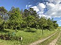 Pflanzenstandort ober dem Bischofsheimer Weg, ND Fläche 01.jpg 4,032 × 3,024; 6.71 MB
-
 Pflanzenstandort ober dem Bischofsheimer Weg, ND Fläche 02.jpg 4,032 × 3,024; 7.75 MB
-
 Pflanzenstandort ober dem Bischofsheimer Weg, ND Fläche 04.jpg 5,472 × 3,648; 10.02 MB
-
 Pflanzenstandort ober dem Bischofsheimer Weg, ND Fläche 05.jpg 4,032 × 3,024; 3.69 MB
-
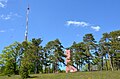 Raichbergturm und Sender Raichberg.jpg 4,928 × 3,264; 2.97 MB
-
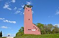 Raichbergturm, Schwäbischer Albverein.jpg 4,928 × 3,264; 2.55 MB
-
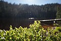
 Ratshauser See am Schlichemklamm.jpg 3,061 × 823; 779 KB
-

-
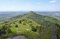 Zollernberg mit Burg Hohenzollern (Blick vom Zeller Horn).jpg 4,928 × 3,264; 3.28 MB
-
 Zollernberg mit Burg Hohenzollern vom Zeller Horn.jpg 4,928 × 3,264; 3.04 MB
-
 Zollernberg mit Burg Hohenzollern, Blick vom Zeller Horn.jpg 4,928 × 3,264; 3.04 MB


.jpg)


,_Tamm-Hohenstange,_2021-05-30,_yj.jpg)
.jpg)

