Category:Admiralty Charts Region R: USA and Mexico west coasts
Jump to navigation
Jump to search
Media in category "Admiralty Charts Region R: USA and Mexico west coasts"
The following 27 files are in this category, out of 27 total.
-
 Admiralty Chart No 1051 Port Angeles to Mangrove Bluff, Published 1887.jpg 16,130 × 11,126; 51.81 MB
-
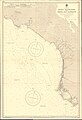
 Admiralty Chart No 1053 Morro de Papanoa to Cabo Corrientes, Published 1961.jpg 16,223 × 11,063; 55.06 MB
-
 Admiralty Chart No 1063 San Pedro Channel, Published 1971.jpg 16,444 × 11,282; 13.84 MB
-
 Admiralty Chart No 1876 Mazatlan Harbour, Published 1848, Large Corrections 1898.jpg 8,132 × 11,061; 12.19 MB
-
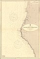
 Admiralty Chart No 2323 Manzanillo Bay to the Gulf of California, Published 1879.jpg 16,333 × 11,089; 43.09 MB
-

-

-
 Admiralty Chart No 2324 Cape St Lucas to San Diego Bay with the Gulf of California, Published 1879.jpg 11,251 × 16,395; 10.56 MB
-
 Admiralty Chart No 2530 Diego Bay to Cape Mendocino, Published 1858.jpg 8,091 × 11,856; 28.54 MB
-

-
 Admiralty Chart No 2839 Columbia River, Published 1897.jpg 16,277 × 10,929; 60.94 MB
-
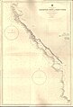
 Admiralty Chart No 3053 Bahia La Paz to Bahia Magdalena, Published 1954.jpg 16,283 × 11,078; 43.85 MB
-
 Admiralty Chart No 3054 Bahia Magdalena to Bahia San Hipolito, Published 1954.jpg 11,081 × 16,227; 52.64 MB
-
 Admiralty Chart No 3056 Bahia Rosario to San Diego Bay, Published 1951.jpg 11,096 × 16,198; 57.52 MB
-
 Admiralty Chart No 3060 Plans in the Golfo de California, Published 1956.jpg 11,052 × 8,368; 25.02 MB
-
 Admiralty Chart No 3120 Bodega Head to Abalone Point, Published 1900.jpg 11,026 × 15,857; 60.24 MB
-
 Admiralty Chart No 3121 Abalone Point to Redding Rock, Published 1900, New Edition 1955.jpg 11,104 × 16,219; 53.13 MB
-
 Admiralty Chart No 3122 Redding Rock to Cape Blanco, Published 1900.jpg 11,028 × 16,135; 49.12 MB
-
 Admiralty Chart No 3123 Cape Blanco to Yaquina River, Published 1900, New Edition 1934.jpg 11,302 × 17,703; 47.79 MB
-
 Admiralty Chart No 3124 Yaquina River to Cape Disappointment, Published 1900.jpg 11,056 × 16,253; 43.82 MB
-
 Admiralty Chart No 3327 Cape San Lucas To Espiritu Santo and Sta. Margarita Is, Published 1903.jpg 24,091 × 16,255; 56.63 MB
-
 Admiralty Chart No 590 San Pablo Bay, Published 1952.jpg 16,286 × 11,089; 39.6 MB
-
 Admiralty Chart No 591 Habour of San Francisco, Published 1833.jpg 13,286 × 9,354; 22.7 MB
-

-
 Admiralty Chart No 591 San Francisco Harbor and Approaches, Published 1952.jpg 16,344 × 11,307; 34.94 MB
-
 Admiralty Chart No 778 Conception Point to Point Pinos, Published 1899, Corrections Copyright 1960.jpg 11,042 × 16,228; 45.61 MB
-


