Category:1 Trueman Street, Liverpool
Jump to navigation
Jump to search
| Object location | | View all coordinates using: OpenStreetMap |
|---|
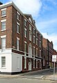
Part of the Grade II listed 135 - 139 Dale Street; merchant's house dating to 1790.
Subcategories
This category has only the following subcategory.
Media in category "1 Trueman Street, Liverpool"
The following 4 files are in this category, out of 4 total.
-
 1 Trueman Street 2019.jpg 3,057 × 4,614; 9.69 MB
-
 1 Trueman Street, Liverpool 1.jpg 1,456 × 1,920; 482 KB
-
 1 Trueman Street, Liverpool 2.jpg 1,488 × 1,984; 628 KB
-
 135 - 139 Dale Street 4.jpg 3,303 × 4,788; 10.42 MB


