Category:1884 maps of Texas
Jump to navigation
Jump to search
States of the United States: California · Connecticut · Delaware · Florida · Georgia · Idaho · Iowa · Kansas · Kentucky · Louisiana · Michigan · Minnesota · Missouri · Montana · New Jersey · New York · North Carolina · North Dakota · Ohio · Oregon · Pennsylvania · South Carolina · South Dakota · Tennessee · Texas · Utah · Virginia · Washington · West Virginia · Wisconsin · Wyoming – Washington, D.C.
| ← 1880 1881 1882 1883 1884 1885 1886 1887 1888 1889 → |
Media in category "1884 maps of Texas"
The following 13 files are in this category, out of 13 total.
-
 Dallas Co., Texas. LOC 2012592048.jpg 10,297 × 11,531; 15.72 MB
-
 Dallas Co., Texas. LOC 2012592048.tif 10,297 × 11,531; 339.7 MB
-
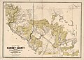 Map of Kinney County, Texas. LOC 2010587200.jpg 13,801 × 10,000; 14.88 MB
-
 Map of Kinney County, Texas. LOC 2010587200.tif 13,801 × 10,000; 394.85 MB
-
 Map of Van Zandt Co., Texas. LOC 2012592082.jpg 6,232 × 5,842; 5.78 MB
-
 Map of Van Zandt Co., Texas. LOC 2012592082.tif 6,232 × 5,842; 104.16 MB
-
 O. W. Gray & Son City of Galveston ca. 1884 UTA.jpg 4,991 × 8,018; 9.91 MB
-
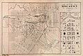 O. W. Gray & Son City of Houston 1884 UTA.jpg 7,809 × 5,272; 17.09 MB
-
 Old map-Gatesville-1884.jpg 7,250 × 4,708; 17.08 MB
-
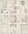 Sanborn Fire Insurance Map from Ennis, Ellis County, Texas. LOC sanborn08519 001.jpg 6,450 × 7,650; 3.99 MB
-
 Sanborn Fire Insurance Map from Ennis, Ellis County, Texas. LOC sanborn08519 001.tif 6,450 × 7,650; 141.17 MB
-

-


