Category:12A Edge Lane, Liverpool
Jump to navigation
Jump to search
| Object location | | View all coordinates using: OpenStreetMap |
|---|
building in Liverpool, Merseyside, England, UK  | |||||
| Upload media | |||||
| Instance of | |||||
|---|---|---|---|---|---|
| Location | Liverpool, Merseyside, North West England, England | ||||
| Heritage designation |
| ||||
 | |||||
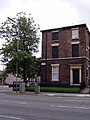
Grade II listed 1830s brick built house on the corner of Edge Lane & Marmaduke Street.
Media in category "12A Edge Lane, Liverpool"
The following 2 files are in this category, out of 2 total.
-
 12A Edge Lane.jpg 4,423 × 3,729; 9.41 MB
-
 Edge Lane, Liverpool 12.jpg 1,488 × 1,984; 633 KB
